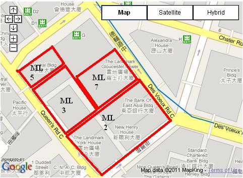
Though these lots have been subdivided, they still retain their parent Marine Lot number.
Get Gwulo's books
Directory
Click on your area of interest to choose from over 30,000 pages about old Hong Kong:
- Images & photos
- View - View galleries - View new - Create - Forum topics
- View - Create - Places & buildings
- View map - View new - Create - Streets
- View map - View new - Create - People
- View - View new - Create - Organisations
- View all - View new - Create - Diaries & memoirs
- View - View new - Create diary - Create page - Events
- View - View new - Create - Jurors lists
- View - Type a page
Or choose a popular article:


Comments
ML7 doesn't look right
Hi Annelise,
The original lots would have run a short distance north from Queen's Rd Central to the shore. So ML 7 looks like it would have been in the sea when the lots were allocated. Any chance that one is in the wrong place?
Regards, David
Please do double check
This is from http://www1.map.gov.hk/gih3/view/index.jsp I'm just reporting what is on the Government site.
I don't know if the lots ran to the low water or high water mark.
Please do double check. Click LOT at the bottom left, and then ML 7.
More on ML7
I took a look at the Government website, and saw six records. They are just fragments of the original lot. One is over on Pedder Street, so I think ML 7 was wider than the box you've drawn.
Then I took a look at the 'Mapping Hong Kong' book for more about the original Marine Lots.
So the lot description "ML 7" was recycled at some point. Until now I'd believed that lot numbers were fixed to a single piece of land, and never re-used. Something new to know.
Regards, David