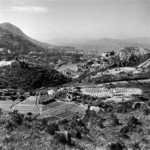
View looking downward from Jardine's Lookout. Is it 1946 Government Stadium??
Get Gwulo's books
Directory
Click on your area of interest to choose from over 30,000 pages about old Hong Kong:
- Images & photos
- View - View galleries - View new - Create - Forum topics
- View - Create - Places & buildings
- View map - View new - Create - Streets
- View map - View new - Create - People
- View - View new - Create - Organisations
- View all - View new - Create - Diaries & memoirs
- View - View new - Create diary - Create page - Events
- View - View new - Create - Jurors lists
- View - Type a page
Or choose a popular article:


Comments
Re: View from Jardine's Lookout
Hi there,
If the year was indeed 1946, what's shown in the photo is most likely the Race course in Happy Valley instead.
Best Regards,
T
re: View Looking Downward from Jardine's Lookout Yr 1946?
Hi Lolau,
If you see sharp photo of Hong Kong that is square-shaped and dated 1946-7, there's a very good chance it was taken by Hedda Morrison. High-resolution copies of her photos are available online - click here for details.
If you find the hi-resolution copy of this photo there, please let us know if it answers the question about what which stadium we're looking at.
regards, David
Re: That's Morrison's photo alright
Hi there,
That was Morrison's photo alright. And just as i recognized, it was showing the Race Course. There is actually a series of photos taken on the same spot while the camera was pointing to other directions.
Best Regards,
T
Thanks.
Thanks. I guess the fields in the photo are more or less at today's Jardine's Lookout Garden Mansion and former So Kan Po Cottage Area. Am I right?
Re: View looking downward from jareine's Lookout Yr 1946?
Hi there,
Go get a decent map with contour line/terrain shown clearly for comparison. Google Map should do, but if you could get one of those 1:10,000 maps of the area it would be even better.
The pass in the middle of the photo, if you compare it with a map, would be where present day Tai Hang Road meets Broadwood Road. Tai Hang Road goes behind the bluff, snaking its way towards Stubbs Road.
The So Kon Po valley isn't even in the photo. The fields as shown in the foreground were most likely part of the present day upper class Jardines Lookout residential area.
Morrison was very likely walking along Sir Cecil's Ride when she took the group of photos.
Best Regards,
T