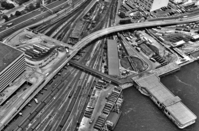
The locomotive Turntable referred to earlier by 'T' is seen clearly here next to the HKYF Co pier. While the turntable has gone I believe the long building next to it is still there today used for housing small KCR freight locomotives. Remarkable in this picture is the extent of the freight transfer yards no longer in use at this location
Turntable-Tsim Sha Tsui East
Primary tabs

Submitted by IDJ
Date picture taken (may be approximate):
Friday, June 15, 1979
Gallery:
Connections:
- Turntable-Tsim Sha Tsui East shows Place Hung Hom railway station [1975- ]
- Turntable-Tsim Sha Tsui East shows Place Former Hung Hom Ferry Pier (1979) for Hung Hom / Wanchai service [????-????]
- Turntable-Tsim Sha Tsui East shows Place KCR turntable (south) [c.1969-c.1993]
- Turntable-Tsim Sha Tsui East shows Place Hung Hom ferry pier to Wanchai & North Point [1979-c.1988]


Comments
Turntable
from the looks of this I would say the turntable was around the area where the northermost block of the Harbourview now sits.
By the way, the terminus shown is Hung Hom, not TST.
Cheers
Phil
Hung Hom Ferry Pier
I just want to ask if the pier is the Hung Hom ferry pier? It has always seemed to me that the Hung Hom ferry pier was a little further to the east, more or less adjoining the erstwhile boundary of the Whampoa shipyard. In today's layout, it would be around the area where the residential development Royal Peninsula is built.
Have I got things wrong completely wrong, or was the one in the photo a specific loading place for goods from the trains?
breskvar
Re: Hung Hom Ferry Pier
Hi there,
In the 1970's there are two piers there. The one shown in the photo was the new-ish (sort of) pier for Yaumati Ferries, projected towards the se. There was another one (was it Star Ferry to Central?) using the shoreline with the pier building runninga bit towards the east where ferries took their berth along the sea front.
One of theHYF routes ran between Wanchai & Hung Hom, the other ran between North and Hung Hom.
Best Regards,
T
Hung Hom Ferry Pier
The complete aerial image of which I posted only a section shows just off to the right a Star Ferry berthed and further east other piers used by the HKYF. The book on the history of the KCR published by the Urban Council circa 1990 has line diagram maps on pages 154 & 155 showing the proposed new terminus and ferry piers to Wanchai in the location of the Star Ferry in the aerial picture, and further east a pier marked for North Point.These line diagrams also show the locations of the turntable and traverser. These ferry piers moved around as reclamation progressed over the years. The present ferry pier has fairly reduced services these days.
Re: Hung Hom Ferry Piers
Hi IDJ,
You are right. Now that you've mentioned it I could recall there was an older HYF pier almost at the corner of the bay. I have mentioned in another threat (some Dockyard thread, I think) that the Hung Hom <--> North Point HYF ferry skimming along the Hong Hom Dockyard where you could observe the water tight dry dock doors in close quarters.
Best Regards,
T
hunghom piers
Dear brekvar:
You can actually see part of the old pier going to Central (1975-1988) (previously goint to Wanchai1963-1975) on the right edge of the picture. In front of the old pier, you can still see the remains of the former bus terminal. Of course in 1975 or 1976, the bus terminal moved up to the new train station. As a matter of fact, those piers at the end of Whampoa Street were still in operation till 1988 when they moved to Hunghom bay center.