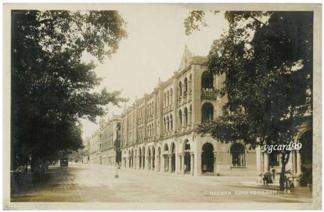
Nathan Road
Primary tabs

Submitted by annelisec
Date picture taken (may be approximate):
Thursday, January 1, 1920
Connections:
- Nathan Road shows Place Junction of Nathan and Mody Roads [????- ]
- Nathan Road shows Place Terraced building on Nathan Rd between Mody & Carnarvon Roads [????-????]


Comments
Re: Nathan Rd
Judging from the bus on the road and Telephone House yet to be erected, this photo woud have been taken around the 1920s
Re: Nathan Rd
Looks like there's a gas lamp in the middle of the street too. Do we have experts on street lighting reading, that could use it to date the photo?
Lamp
If this is the same photo, as would seem, that came from eBay here:
http://cgi.ebay.com/HONG-KONG-Kowloon-Nathan-Road-Real-Photo-Postcard-/120614631136?pt=LH_DefaultDomain_0&hash=item1c153136e0
there seems no date offered. It looks much more like 1920s than 1950s though.
Which intersection is this ?
Which intersection is this ? I'd like to link the photo to a building location.
Re: intersection
Looking northbound on Nathan Road. Cameron Road junction on the right.
Further south?
I don't think we're as far north as Cameron. Take a look at this 50s photo:
Looking north, we start with Chungking arcade. Past that is a terraceed building with a flat-if-crinkly roof (please excuse the technical terms).
Next is a terrace with a big triangle gable at each end, and smaller ones in the middle. If we move over to the 1920s photo, I think that's the photo in the foreground.
Continuing north with the 1920s photo, and the next terraced building has several similar-sized triangle gables along the roof. I think that's the same building that had Gingles Restaurant.
Re: Further south
Re-checked the location and you are right. That would make the intersection in the 1920s photo as Mody Road.
A better referenced photo showing both sides of Nathan Road. Note the gas lamps in the centre of the road have disappeared.