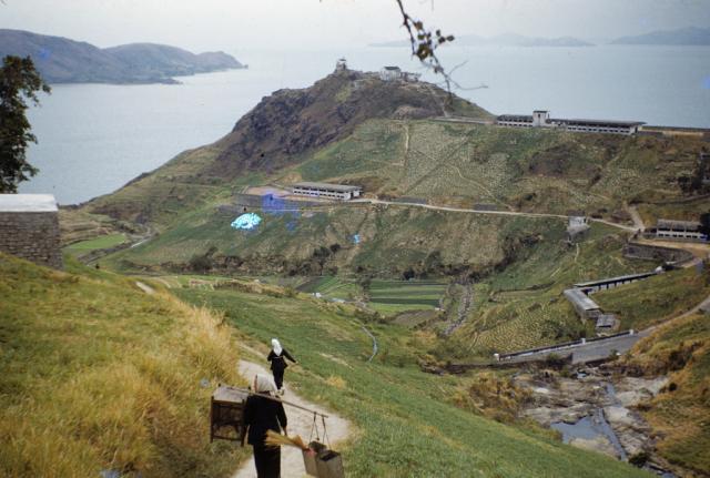
1950s Pok Fu Lam Dairy Farm
Primary tabs

Date picture taken (may be approximate):
Friday, January 1, 1954
Gallery:
Connections:
- 1950s Pok Fu Lam Dairy Farm shows Place The 'Dairy Farm' farm, Pokfulam [1886- ]
- 1950s Pok Fu Lam Dairy Farm shows Place Victoria Road Bridge over river above Waterfall Bay [????- ]


Comments
Stone Arch Bridge on Victoria Road
Hi,
I couldn't quite figure out the location of the rocky stream in the foreground of this photo until I saw a similar stone wall feature during my exploration of the stream above Victoria Road last time. It is right between the junctions of Cybeport Road and Wah Chui Street. The strong odour of the filthy flowing water will certainly get your attention.
You will encounter such stone wall remains when you follow the stairs from Victoria Road.
The same stone wall is still very much intact nowadays.
If you walk all the way to the other end of the stone wall, you will notice a rather ordinary bridge.
But if you get closer enough, you will notice the presence of a stone arch bridge right below the modern-day pavement.
Stone Arches
Take a look of the inside and you can see the expansion section of the bridge at far end.
It is time to head back to the stream to explore further. Residence Bel-Air in the background.
If you go further up the stream, you will find a section of stream bed with Pokfulam Gardens in the background. Once I noticed there were flushed toilet papers all over the rock surface, I turned away and left the scene immediately.
If you want to explore further upstream, you will need to go toward the left side of the stream where you will find a trail with the ribbon indication. This will lead you to another clearing where there is a pool and a waterfall. This is not the same waterfall as the one below Pokfulam Road and Chinese Cuisine Training Institute.
Regards,
Freddie
Dairy Farm
Thanks to Moddsey for posting the pic at the start of this string and to Freddie for following up with his discovery of the old bridge and warning me about the smell! Omg, it stinks! There should be a public health warning at Waterfall Bay, into which this stream runs.
Anyway, HT Wong's excellent collection of photos on flickr has a similar view.
This one is taken from a slightly wider angle, and at its right side shows part of a circular stone building not visible in the first shot. Zooming in on the brilliant map provided by Lands Department shows a dotted circular shape in roughly the same position, just to the north of the bridge over Victoria Road.
Could the old stone structure still be there?
Yes, long abandoned, but still there. It's always nice to find something old and forgotten in modern Hong Kong. Here's the view from the "front", downhill side.
A narrow vertical vent runs up the side.
I guess its function was to allow easy access to the interior at various levels.
This is the view of the top. The 1955 photo suggests it then had a conical roof, and I seem to remember I've seen photos of a similar structure with a roof. If so, it's long gone.
I presume the structure was a food storage facility for the animals kept at the Pokfulam Dairy Farm. It's not difficult to access, hiding in the trees about 100 meters off Victoria Road.
Stone Silo