See also annotations on Flickr. The shipyard is attributed to HYK. Is this Hong Kong Ship Yard on the 1956 Kowloon map?
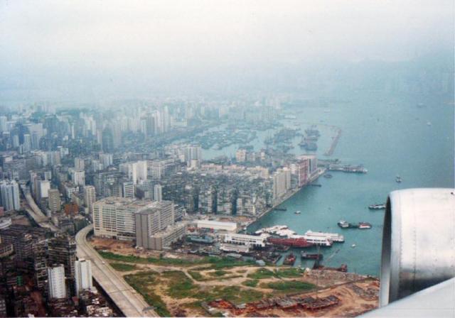
1987 Sept aerial view
Primary tabs

Date picture taken (may be approximate):
Tuesday, September 1, 1987
Gallery:
Connections:
- 1987 Sept aerial view shows Place Former Tai Kok Tsui Ferry Pier [????- ]


Comments
1956 Kowloon map
I think the Hong Kong Ship Yard on the 1956 map was a bit further inland than the shipyard shown above, roughly where the building marked "Industrial Building complex..." on Flickr is on this photo.
Hong Kong Ship Yard
Greetings. Just found these two photos about the Hong Kong Ship Yard, in its still busy days. The neighbourhood has seen many changes since then, roads likely realigned and the elevated roadway makes it difficult to precisely spot it on modern map. So these old maps are a great help. Comparing this aerial photo with current Google map, I estimate that the ship yard was at the spot where the elevated roadway has "just" branched off to two directions. Regards, Peter
Hong Kong Ship Yard
Found on Flickr a similar image taken some 13 years earlier:
On this one, the ship yard is still existing. In the 1987 one, the harbour north of the Cosmopolitan Estate has been reclaimed, the the ship yard is gone.
P.S. Peter, as we have three images of Hong Kong Ship Yard now, I created a place for this yard.
Another one from 1960
Found another one from 1960
I cropped the part of Cosmopolitan Docks and Hong Kong Ship Yard. It seems that the building of Cosmopolitan Estate has begun already.
Hong Kong Ship Yard
Thank you Klaus, for the new page on this ship yard. Regards, Peter