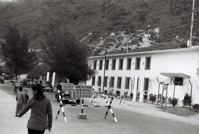
Can anyone identify which of the checkpoints this might have been? The building has a tall barbed wire fence in front of it, so it was probably a military one, and the checkpoint seems to have been a temporary one. The car's registration number is 7303.
Check Point
Primary tabs

Submitted by Andrew Suddaby
Gallery:
Connections:
- Check Point shows Place Castle Peak Police Station (2nd generation) / Marine Police admin facility [c.1955-c.1992]


Comments
There's a small sign at the
There's a small sign at the right of the road. At full zoom it looks to have "HKP" on the top, so maybe the building is a police station?
Re: Building
I noted the HKP sign too. At first I thought it was the Pat Heung Police Station but the mountain behind disproves this notion. May be Castle Peak Police Station but I have not seen old photos of it. These police stations were built in the late 40s and early 50s and were more or less the same design.
I also note in suziepie’s video screenshots of the drive around the NT, a police station can be seen.
I've been wondering why
I've been wondering why Malcolm would take a photograph of a checkpoint. In 1958 one of my pals hired a car for the day from one of the Sergeants on the camp. This was all unofficiai and I have sometimes wondered whether the insurance covered him. Hoiwever, ths enabled us to drive 'the circuit' of the New Territories and several of the colour slides in my 1957/8 gallery were taken on that day. It is very possible that all Malcolm's photographs taken in the Castle Peak area and beyond were as a result of a similar car journey. and not as I previously wrote one done by public transport. If so, their car being stopped at a police checkpoint would be sufficient for Malcolm to record this, to us, rather unusual event - and of course ti could have happened anywhere, but most likely on the circuit of the New Territories. Andrew
NT
I'm not sure how many spots there are in the NT where the main road sits so close to what looks like quite a steep hill. If this is a round NT trip then it should be easy to discount most places.
Thanks Phil.
Thanks Phil.
I cannot be certain that it was a round the New Territories drive, but it is very likely. Is it possible that the photograph might have been taken in Kowloon or the outskirts, where there were quite a lot of hills, some with steep sides, quite close to the roads?
Regards, Andrew
1950s NT Checkpoint
This may be the scene in the opposite direction.
An interesting suggestion. At
An interesting suggestion. At first sight it does look to be the same place but I think that there are several differences - the front of the building seems to lack a porch and at least two of the front windows have small 'fan lights'. The hill appears to be descending to the left behind the building, whereas on Bill's photograph it it very high there. It looks as though the two children might be standing on a bridge but, if that is the case, it would only be over a very narrow ditch or stream, so that isn't likely to be much help!
same place
actually, I think it may be the same place. The question is where? Is there a list of Police Stations available for the 1950's?
Yes, it looks like the same
Yes, it looks like the same building to me too.
I haven't seen a list of Police Stations, but the 1952 map has them marked. (The link shows Ta Ku Ling Police Station as an example, but that's surrounded by flat land so isn't a match.)
Looked at the 1952 Map
Looked at the 1952 Map. Castle Peak Police Station is adjacent to a high hill.
Thank you everyone. If the
Thank you everyone. If the Castle Peak Road police station was the one at Wong Ka Wai just North of milestone 20, that would be a distinct possibility. The very high hill/mountain behind Malcolm’s photograph looks right and there are several more of his photographs taken in that area. Andrew
Castle Peak
There is a very distinctive bend in Moddsey's reverse view that doesn't tie up with Castle Peak police station. Plus, I know the older map buildings marked aren't necessarily to scale but some effort seems to have gone into at least making the building shapes a little more detailed. The police station on the map just looks like a tiny regular box rather than the extended structure seen on the photo.
Edit: is it possible the HKP sign was for the checkpoint only and the large building was a military installation?
An interesting dilemma. I’m
An interesting dilemma. I’m away from home with poor access to the Internet and no access to my own computer. On Malcolm’s photo, I notice that either there appears to be a wall immediately in front of any door below the porch or that the doorway has been blocked off. There are also two flag poles - usually just one would do, and there is a strange pole on the right with rungs(?) up,it. The latter might be of interest to any aerial erectors in the Gwulo community, who might know whether it was police or military?
My error. The pole on the left has a loudspeaker on it so,it is not a flag pole.
Police Station
Following on from this post, it looks as though is building quite possibly is a Police Station after all. However, I am also equally convinced it's not in Tsuen Wan either. See the image below for the old Tsuen Wan station.
Re: Police Station
Hi There,
If we just concentrate on the building itself, this one looked very much like the Pat Heung Police Station just posted earlier today. If there are a few more police station using the same blueprints for construction then we should be able to narrow down the location.
T
Hi T. I shall leave it to you
Hi T. I shall leave it to you experts to sort this one out - but I shall follow the dialogue with interest! Regards,Andrew
Castle Peak
Guy Shirra kindly posted this to the FB group, "The Royal Hong Kong Police Force", where several ex-HK policemen identified it as the Castle Peak Police Station.
The police station in this photo was newer and a bit further south than the one on the 1952 map, see: https://gwulo.com/node/45964
mystery solved
many thanks David and Guy.
Thank you everyone. Castle
Thank you everyone. Castle Peak it is!
Another Photo
Castle Peak Police Station
A colour photo of the Castle Peak Police Station-cum-Checkpoint can be viewed here