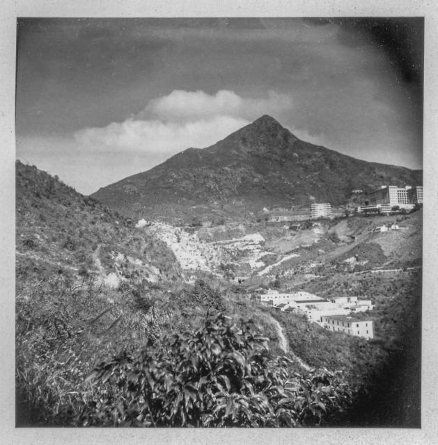
39. The Peak from Pok Fu Lam.jpg
Primary tabs

Submitted by njkitto
Date picture taken (may be approximate):
Thursday, January 1, 1948
Gallery:
Connections:
- 39. The Peak from Pok Fu Lam.jpg shows Place Queen Mary Hospital [1937- ]
- 39. The Peak from Pok Fu Lam.jpg shows Place Chinese Christian Cemetery, Pokfulam [1882- ]
- 39. The Peak from Pok Fu Lam.jpg shows Place High West (Sai Ko Shan) [????- ]


Comments
High West from Mount Davis
Thanks for posting a lovely set of photos with such a wide coverage of the urban and rural areas.
The peak dominating this pic is High West. The large building on the upper right side is Queen Mary Hospital. The area of light structures just to the left of centre, that disappear behind the diagonal ridge descending from left to right across the photo, is the Chinese Christian Cemetery. The photo was taken from somewhere on Mount Davis, possibly Victoria or Mount Davis Roads.
High West from Mount Davis
Thank you for the correction. As mentioned elsewhere, I stuck with my father's captions, although I probably should have corrected the ones that were obviously wrong ... this is a good example as I lived in Pokfulam from 1983 until moving to Clear Water Bay in 1992 and so am well aware that this is High West and not The Peak. The other point is that I am really only looking at these photos more fully now that they are online. The original photos, with only a few exceptions, are all small contact prints (I don't have the negatives). After scanning the prints my priority was trying to clean them up as much as possible and I did this while being almost oblivious to the subject matter ... sounds odd perhaps, but prolonged 'spotting' tends to do that!
I've spent the last 12 years or so visiting the Mainland to photograph surviving buidlings form the Treaty Port era. In-between those trips, I have been photographing our Declared Monuments, but have yet to visit the TWGH's Coffin Home which I expect is amongst the nearer buildings in this photograph.