Praya East Reclamation Railway
Primary tabs
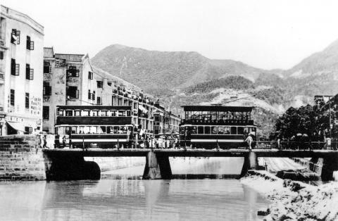
Reader IDJ sent this interesting photo, showing a temporary railway laid along the western side of Bowrington Canal. He points out that these temporary railways were quite commonly seen at large construction sites.
The reason for the rails is given in the 'City of Victoria' book, which says they 'were laid to transport sand and soil removed from Morrison Hill to the waterfront for land reclamation furing the Pray East Reclamation project.'
Page 66 of the 1921 report for Public Works shows it was quite an extensive railway during the life of the project:
"The Contractors placed orders for four Locomotives, one mile of track (35 lbs. rails), two miles of track (30 lbs. rails), one mile of track (12 lbs. rails), fifty Decauville Wagons and wheels, axles and axle boxes for one hundred 3 1/4 cubic yard side-tipping wagons."


Comments
1920s Praya East Reclamation
A photo of the Praya East (Wanchai) Reclamation.
re: 1920s Praya East Reclamation
Moddsey, thanks for pointing out this photo. If I zoom in I can see a couple of thin lines running across the reclamation, which could well be some of those railway lines. And at 3 o'clock there's a slightly thicker line that looks like it could be a line of wagons.
I get a kick out of re-visiting these old photos and seeing more detail as we learn more about them. I'll pay attention to any future shots we get of the reclamation under way, to see if there's any more evidence of the railway lines.
Regards, David
1920s Praya East Reclamation
A clearer image of Moddesey’s picture of the Wanchai site reclamation work appears in the book ‘A Century of Hong Kong Roads and Streets on page 75. Three widely spaced railway tracks can be seen and a couple of groups of wagons.
The tracks in the Bowrington Canal were not dug deep enough to allow locomotives to pass under the bridge so wagons had to be pushed through to be picked up by other locomotives on the opposite side. One report says that the track-work in the canal was allowed to flood at high tides so it must have been pretty unsavoury working with the wagons at track level during low tides.
In images of the Kowloon Tong Estates site formation work, narrow gauge rail tracks can be plainly seen. Another image shows narrow gauge rail tracks disappearing further east which may well have connected to the rail system at the Kai Tak reclamations. Both projects were in progress about the same time.
None of these systems appear to have been in place long enough to be included on maps of the periods.
It may be recalled that when the new airport and railway was being built that the MTR ran a series of adverts with a photograph showing an ancient industrial steam locomotive pulling wagons referring to it as ‘The First Airport Railway’
It’s surprising few photographs of these systems have surfaced over the years as they were significant civil engineering projects that are usually well documented especially the government ones.
IDJ
re: 1920s Praya East Reclamation
Thanks IDJ. I've got a copy of that book, but hadn't realised this photo was there - you're right it's a sharper view.
I wonder if the photos have been thrown away over time. I can imagine if someone was looking through old family photos and deciding what to keep, a stack of photos of construction underway might well be assigned to the bin!
Regards, David
1920s Praya East Reclamation
Does anybody know where the buildings were located in the foreground, especially the house to the right of the word 'Peak'?
Thanks BJ
1920s Praya East Reclamation Photo
The photograph was taken from Kennedy Road. If I were to guess where the photographer was standing, it would be on Kennedy Road overlooking Monmouth Terrace and the western end of today's Queen's Road East.
1920s Praya East Reclamation Railway
Praya East Reclamation Plan as in May 1920