Bonham Towers ("Western Barracks"), 88 Bonham Road [c.1970- ]
Primary tabs
Submitted by Admin on Sun, 2010-03-14 21:09
Current condition:
In use
Date Place completed:
c.1970-01-01 (Year, Month, Day are approximate)
An anonymous reader asks:
Looking at Google maps, where 88 Bonham Road is now (Bonham Towers), Google has the marked as 'Western Barracks'. Does anyone know anything of these purported former barracks ?
Tags:


Comments
re: Western Barracks
As far as I know, they are still barracks.
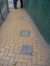
If you look down as you walk along Bonham Road, you'll see several 'D.L.' stones embedded in the pavement. They mark the boundary of a Defence Lot, a piece of land used by the armed forces.
In the 1990s there was a small NAAFI shop on the right as you looked in to the carpark. I'm not sure which branch of the British armed forces used it.
Since the handover, it should be quarters for the PLA.
Western Barracks Bonham Road
These were "Bonham Towers," Royal Navy high rise living quarters in the 1980s-1990s, I don't know what preceded them.
Defence Lot 5
I've attached photos of the markers in the pavement.
1842 - Western Barracks
Friend of China 6.10.42 edition
Letter to the Editor
It is now possible to ride a good horse along the beach from Western barracks to Sookunpo, a distance of about 4 miles. You could never do that in Canton. Not only that but one of the highest peaks is being levelled and a house erected on its summit. New sites are popping up everywhere and the whole island rings to the sounds of saws and hammers.
I served in HMS TAMAR from 78
I served in HMS TAMAR from 78 - 80- and lived in this building in Flat B13. There was parking on the ground floor together with a NAAFOI shop, the next level we built a families social club which replaced the tiny bar on the floor above where the kiddies playground was. The rest of the building was Navy married quarters with wrens quarters in the Penthouse until they moved down to Tamar when the Prince of Wales building opened.
Re: 1842 - Western Barracks
Hi annelisec, thanks for the excerpt. However, I believe the location of the Bonham Towers was never called "Western Barracks" before 1997, so the 1842 Western Barracks must be a different place, likely located much closer to the shoreline.
Bonham Towers
Well done, C! It would have been helpful if someone had early looked for the answers to the following:
1. Who holds the lease for the land now, and if there was a previous lessee who was he?
2. Who developed the lot and paid for the construction?
3. Who lives there now?
The answers to these questions will confirm that this was a private development on private land. It is a high rise residential building built sometime in the early 1970s. It is not and never was a "barracks".
I think the building was rented by the Navy to replace the Naval quarters given up in Wong Nei Chong Road facing the Football Stadium.
I don't know what DL stands for, but those stones situated as they are obviously are not boundary markers. They are too close together. Perhaps they were found elsewhere on the site and somebody had the bright idea of imbedding them in the pavement here. More likely to be something like "drainage line".
And Annelisec might have given further thought to the matter before rushing to the archives to produce that excerpt. We don't know where it comes from or who wrote it, but the reference was most likely to the western camp or cantonment - i.e Sai Ying Pun. Certainly nothing to do with Bonham Road.
The culprit is Google. Wonder where they got "Western Barracks" from? Wherever it came from, it should not be written so firmly into the public domain to mislead everyone. Red faces all round, I suggest.
The excerpt
The archived excerpt can be found here: http://sunzi1.lib.hku.hk/hkgro/view/g1842/728492.pdf halfway down column one of page three, although the version pasted above seems to be paraphrased somewhat. I'm also not sure what it has to do with Bonham Road. Interesting letter though.
Bonham Towers/Western Barracks
Hi. Bonham Towers were military quarters included among sites handed over by the British government to the PLA after the Handover, according to the transfer agreement on the UN website:
http://untreaty.un.org/unts/120001_144071/6/10/00005061.pdf
According to that document there were five sites to be handed over on HK Island. Stanley (Chek Chue) barracks, Prince of Wales (Central) Barracks, Headquarter House on Barker Road, Queens Lines (Ching Yi To) in Admiralty, and Bonham Towers.
According to the following Legco document from 2000 listing five closed military sites on HK island, four are as above. The fifth, Western Barracks, we can deduce corresponds to Bonham Towers .
http://www.legco.gov.hk/yr99-00/english/subleg/negative/ln171-e.pdf
Sai Ying Poon - Wikipedia
In the Chinese language, Sai (西) means "west" and Ying Pun (營盤) means "camp", especially military camp. It was where early British military stayed.
Bonham Towers
Thank you, 80sKid. I stand corrected. But are we sure that what was handed over was not the unexpired part of a rental agreement? Who built Bonham Towers and when? But whatever the modern day situation, I remain sure that what occupied this lot before Bonham Towers was built was not a military barracks.
Bonham Towers
Hi Anon. My understanding is military sites were owned by the UK, then Chinese governments via their respective armed forces, and weren't subject to any particular leasehold provided they were used for purposes of defence. I don't know what preceded Bonham Towers but DL certainly stands for defence lot. DL 1 is Central Barracks by Tamar. Incidentally, the government's Geoinfo map also gives Western Barracks as alternative name; http://www1.map.gov.hk/gih3/view/index.jsp. I don't know the current status of the buildings now.
2. The military sites handed over to the Garrison shall be used exclusively for defence purposes. The right to use the military sites shall not be transferred and the sites shall not be made available to others for purposes other than defence. If a site used by the Garrison is no longer needed for defence purposes, it shall be handed over, without compensation, to the Government of the Hong Kong Special Administrative Region for disposal.
Bonham Towers
Most grateful to you 80sKid. I retire hurt, but not out.
Interesting to know how Bonham Towers came to be built. Most unusual if the colonial HKG built this multi-storey building to accomodate service personel. Perhaps they bought it over from a private developer. I would guess also that the classification Defence Lot came into use in connection with the negotiations over the hand-over.
Tuesday 14/10/1969 This
Tuesday 14/10/1969
This draft was supposed to be married accompanied. In fact our wives couldn't join us until after the first six months, as our married quarters hadn't been completed yet. Getting nearer completion date my oppo Grumpy and I went to view the flats. My flat was numbered A23 and right up at the top of the skyscraper called Bonham Towers, only the Wren's penthouse was higher. On the day of the visit the lifts weren't working yet. You've probably guessed it, we walked all the way up those stairs, even though the flats at the bottom would look exactly the same as ours!
more at http://www.axfordsabode.org.uk/david08.htm
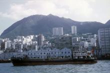
View of and from Bonham Towers
http://picasaweb.google.com/dp.davies/1970S7074#
Bonham Barracks ?
a battery of three guns was located slightly to the west of a stream (running along the alignment of the current Water Street) at West Point. As well barracks were constructed up the hillside all the way to what is currently Bonham Road.
Bonham Barracks?
Unfortunately, Annelisec, Carl Smith does not appear to have given his source. It is possible that he had before him Pottinger's map of 1842. "Battery 3 guns" is marked thereon, and south of that is marked "Volunteer barracks". But if Pottinger's map was his sole source, then I would question the validity of his statement that "barracks were constructed up the hillside all the way to what is currently Bonham Road". It is difficult to locate the battery of three guns from Pottinger's map, and even more difficult to place the Volunteer barracks. But the likelihood is that the battery was on what became Belcher's Fort, which is more than "slightly" to the west of Water Street.
In any case, I don't see what this has to do with the site of Bonham Towers. Even if the site of Bonham Towers was, over a hundred years ago, the site of military barracks, this is not the reason why Bonham Towers became guarters for service personel.
I have conceded that DL stands for Defence Lot, but I think this designation came into being with the Sino-British negotiations. If this had been military land it would surely have been WDBS. I do not think it is a coincidence that this site is DL5 while Prince of Wales Barracks is DL1. That is how they are shown in the appendix to the agreement on military sites.
Re: Bonham Towers
I tend to agree with Anon that Bonham Towers has no direct bearing with the barracks or camp at Sai Ying Pun.
As far as I understand, the camp at Sai Ying Pun was shortlived.
moddsey
Westpoint Barracks
At "Westpoint Barracks" (above Pokfulam Road), where the Indian troops had lost nearly half their number in 1842, sickness was so universal in 1843, that the European troops stationed there were hastily removed (July 20, 1843) on
board ships in the harbour.
Europe in China, Eitel
eBook - read the original - http://www.archive.org/stream/europeinchinahis00eiterich#page/192/mode/2...
Westpoint Barracks
Yes; well to the west of to-day's Bonham Towers.
Re: A battery of three guns
Hi there,
I also tend to believe the mentioned battery with three guns was very likely the Belcher's. Assuming it was really a barrack before the Bonham Towers were built, if you look up the GeoInfor Map and select the Detailed Map option, you should be able to see quite a few streams still exist today. One of them run just besides the towers. This streem seemed to go sub-terrean at Bonham Road and go down Hing Hon Road, then along Water Street and to to the harbour.
A bigger stream runs through the HKU Campus and then go sub-terrean across Pokfulam Road, then down Hill Road. I believe the Stream before the battery means Hill Road.
By comparing the scan ruler the Belcher's is slightly more than 0.5 Km away from Bonham Towers. So at the Bonham Road/Pokfulam Road level it is within walking distance.
My 2 cents,
T
Western Barracks / Bonham
We can add "1 & 2 Prospect Place" to "previous places"
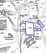
Western Barracks / Bonham Towers are where these two lots were
IL 1714
IL 1878
Google still shows Prospect Place, but it appears that the PLA have taken over the road completely. The red line is where the Lands Department currently shows "Prospect Place" and also show
1-2 PROSPECT PLACE
1-2 光景臺
Bonham Towers
These Inland lots numbers are still in existance to help place the lot in context.
IL 1096 - Swire Hall (Student Residence)
IL 1880 - St. Clare's Primary School
IL 1924 - Chinese Rhenish (Lutheran)Church
See the 1924 map snippet:
Bonham Towers
Is that u taff ex lro
Is that u taff ex Leo from the commcen in tamar
Construction of Bonham Towers
A picture of Bonham Towers under construction can be found here: http://gwulo.com/atom/19344. Its the building in the middle left of the photo covered in scaffolding. This dates completion to 1970 or thereabouts
88 bonhomie towers
i moved into this building when it was first built in I think it was between 68-70, I was in the duke of Wellingtons regiment stationed at Stanley fort (68-71). We were transported by 4 ton vehicle daily to Stanley.
Bonham Towers
I am planning a nostalgic (bucket list) trip back to Hong Kong with my eldest son (born in Hong Kong 1972) and came across this website while doing some research.
We lived in Bonham Towers 1971-1973, while I was serving at HMS Tamar. At that time Bonham Towers was the main married quarters tower block, mostly for Royal Navy families, with the penthouse being used for single WR(E)NS accommodation. We were moved to there after a few weeks of being accommodated way out in the sticks on Pokfulam Road, in a block of flats with locals as neighbours, which was a bit of daunting for a very naive and young couple (with pregnant wife), who had no idea what to expect in Hong Kong ! We enjoyed a great 2 years there.
Vivid memories of the Mid Levels landslide on the hill behind Bonham Towers in 1972, which caused a tower block to collapse and slide down the hill with many people killed. It followed torrential rain during Typhoon Rose.
1972 landslide
There are photos and memories of the landslide on Kotewall Road at http://gwulo.com/atom/18659