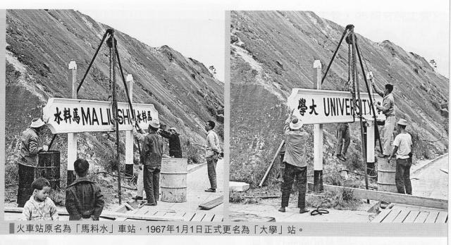
I found these before and after shots of the old Ma Liu Shui/new University KCR station in the latest Chinese University alumni magazine. These photos were taken on January 1, 1967.
University Station, 1967
Primary tabs

Submitted by Susan B-K
Date picture taken (may be approximate):
Sunday, January 1, 1967
Gallery:
Connections:
- University Station, 1967 shows Place Ma Liu Shui / University Station [1956- ]


Comments
馬尿水 - horse pee
I took a Cantonese course there. My teacher remembers when the only way to get there was by boat. Oh, and the name, 馬尿水, she told me means horse pee :)
The story goes that the Govenment changed the character on the sign to 馬料水 changing the meaning to - watering place for horses - to make it less offensive.
I like both stories, myself.
University Station
A number of Cantonese names for coastal locations in HK are offensive. This is because the Royal Navy surveyors charting the coastline, in the 1840s onwards, asked the local mariners they encountered what these places were called-with predictable results. (I have been told this also happened in some coastal areas in Africa). Some of these bawdy names have dropped out of use, but others survive, with more decorous people often deliberately mispronouncing them. I'm afraid some are very obscene indeed, so I had better not list them here!
I say you should list them !
I say you should list them ! You can use *** to be "decorous". If 10 year old Chinese girls who live nearby hear and use the names all the time, then surely we can too. If a gross name from 160 years ago is still in use, well, that's history :)
Old names, new names
Hi there,
I remember there are books talking about these out there. Some local forums might also have partial lists of these.
Talking about horse shit and places, we have 馬屎洲 / Ma Shi Chau special area in the New Territories, which is part of the Geo Park now.
To name a few more old names vs new names:
咸田 Ham Tin / 藍田 Lam Tin
老虎岩 Lo Fu Ngam / 樂富 Lok Fu
爛地 Lan Tei / 藍地 Lam Tei
We might as well build up a old name vs new name vs aliases vs similar names in different locations for places list here as a new topic.
Best Regards,
T
Bawdy place names
Yes, now we know they exist, we're going to have to see the list! (Feel free to send to me by email if you'd like me to post them up.)
I'm also interested to have a list of old / new names. As well as changes to chinese place names, there are also plenty of old english place names (eg "Stanley View") that are referred to in old records, but are no longer in common use.
Regards, David
We need several columns 咸田
We need several columns. Disclaimer, I used Google Translate:
咸田 Ham Tin - Salt Field / 藍田 Lam Tin - Blue Field
老虎岩 Lo Fu Ngam - Tiger Rock / 樂富 Lok Fu - Wealthy Music (?)
Re: We need several columns
Hi there,
The Google translation for Lok Fu isn't even close. "Jolly Rich" or "Happily trying to get Rich" is more likely for that if you translate it literally. I wonder who approved such changes back then. Lok Fu was still Lo Fu Ngam before the MTR started running there.
As for Ham Tin, I would use "Salty Fields' or 'Alkaline Fields' instead.
Anyway...... I will make up a proposed table for this over the weekend for further discussion.
Best Regards,
T
Re: Columns for the table....
Hi there,
How about:
Current Name, Approx. Switch over Date (Optional), Old Name, District, Alias, Remarks
Best Regards,
T
Bawdy place names
Ho Lim-Peng writes:
Oh, alright then.
David, Perhaps you can decide whether to put all these up or not. In each case, of course, the obscene, rather than the biological, Cantonese expression is used
These places are in the Sai Kung Peninsula- Mirs Bay areas:
Fan Kwai Lan Foreign Devil's Penis
Ham Lun Kok Oral Sex Point
Gau Tau Penis Head Rock
Ngau Shi Wan Cow Shit Bay
Hai Si Wan Vaginal Discharge Bay (this one seems, mercifully, to have fallen from use. I have seen it on a 1960s chart)
I have been told there are others, including, somewhere or other, a Pubic Hair Rock.
I'm sure Gwulo fans can come up with some more.
Around the the time of the handover, an august body with with the quite inspiringly dull title of the Place Names Board was trying to get these names expunged, hopefully it failed.
Best regards
Ho Lim Peng
re: Bawdy Place names
Lim-peng - you weren't kidding!
Any idea if the chinese characters on current maps still follow the original meaning, or have they been sanitised like the Ma Liu Shui example above?
Regards, David
re: columns for table
T, is the 'Alias' column needed? Won't the Old and New cover the different meanings already?
Regards, David
Bawdy Place Names
Sorry, it has been some time since I had access to Hong Kong charts. A quick bit of research indicates that around 1998 Gau Tau became Shek Ngau Chau (Turtle or possibly Unicorn Island) lin Marine Department communications.
Re: columns for table
Hi there,
It's just for brain storming. I suggested an alias column becaue some local villagers might still be calling the location using their own dialect. But we could put these into the Remakrs column anyway....
Best Regards,
T
Re: Bawdy place names
Hi there,
Quote>>
Hai Si Wan Vaginal Discharge Bay (this one seems, mercifully, to have fallen from use. I have seen it on a 1960s chart)
End Quote>>
I think I might have located this one. It might have been the bay behind Wong Yi Chau, just a few hundred metres from Sheung Yiu (上窰). The location is now called Hei Tzi Wan (起子灣).
Best Regards,
T
Re: Bawdy place names
Hi there,
I believe I have located this while browsing through the 3rd edition of the Sai Kung & Clear Water Bay Country Series Sheet 4 (1986)
Quote>>
Fan Kwai Lan Foreign Devil's Penis
End Quote>>
This island is just a very short distance north of Basalt Island with the label 番鬼倫洲/Fan Kwai Lun Chau next to it. However it has a proper English name also on the map: Pyramid Rock.
Pyramid Rock is listed on the latest version of the Countryside Series.
Best Regards,
T
That seems to be the correct
That seems to be the correct place-I didn't know it had been renamed in that way.
regards
HO Lim-peng
Bawdy Place Names
Yes, that's the one! I wonder if the bawdy name still appears anywhere.
regards
HO Lim peng
Re: Bawdy Name Places
Hi there,
I didn't realize I have bought the 4th edition of the Sai Sung & Clear Waterbay countryside sheet 4 (1989) and lo, Fan Gwai Lun Chau is still there.
I have spotted another one. :-P
On the North North East of Ku Tsui Chau, very close to the tip, lie Ham Lun Kok (含倫角). Well, at least they did not put in the exact bad language words. The location is called Yau Lung Kok (游龍角) in the Edition 11 of the map (2010). Yau Lung literally means a crusing dragon.
Best Regards,
T
Bawdy Place Names
I remember this was one of the name changes the Place Names Board was pushing for on the 1990s - it looks like they succeeded.
regards
HO Lim -peng