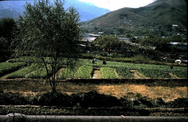
My grandparents took this photo in 1974. Does anyone have a clue as to where it was taken?
Get Gwulo's books
Directory
Click on your area of interest to choose from over 30,000 pages about old Hong Kong:
- Images & photos
- View - View galleries - View new - Create - Forum topics
- View - Create - Places & buildings
- View map - View new - Create - Streets
- View map - View new - Create - People
- View - View new - Create - Organisations
- View all - View new - Create - Diaries & memoirs
- View - View new - Create diary - Create page - Events
- View - View new - Create - Jurors lists
- View - Type a page
Or choose a popular article:


Comments
Kadoorie Farm?
that's my wild stab in the dark. However, the large pipe in the foreground looks like the feed from a reservoir (such as the one that pipes water from Plover Cove), so I'm not sure.
basically without more ridgelines and mountains to help, it could be almost anywhere. Sorry.
Re: - New Territories photo, 1974.
Hi there,
It could be anywhere along the railway between Taipo & Lo Wu. There seemed to be some graves at that spur and these might still be there. If only we could have matches with other photos.....
Best Regards,
T
Re: New Territories photo, 1974
Thanks! I know my grandparents got off the train at Sheung Shui. I can post another photo of that. The station still has the old signage. So if this photo is somewhere between Taipo and Sheung Shui, does that mean that Shatin was more developed than this back in 1974?
Re: New Territories photo, 1974
I think T is right. Assuming this was snapped from the train then the terrain doesn't look right for Shatin. There are a couple of places in Tai Po that have similar terrain but I think this is more likely between Tai Po and Fanling or beyong Sheung Shui.
I may take a trip up to Sheung Shui later in the week and see if anywhere looks similar. Other than one spot near to Tai Po Kau, the railway follows pretty much the same path as it used to pre-electrification (as far as I am aware).
Re: New Territories Photo,1974
Wow, thanks so much, Phil. I you do get a chance to ride up that way, I'd love to hear your thoughts. Does anyone know if it was possible in 1974 to ride beyond Sheung Shui? Things were still turbulent in China then, so I wonder if you needed a special permit to make it all the way up to Lo Wu.
I did take the train up to
I did take the train up to Sheung Shui afew weeks back and looked at both sides of the track but wasn't able to spot anywhere that was similar to this. I suspect the usual culrpit of rampant development has already put paid to the hillside - however, next time I might take a print of this up so I can compare the other hills. Sorry :-(
Railway near Hong Lok Yuen
This would be the section of track between Hong Lok Yuen (formerly a farm) going north to the corner just before the old soy sauce factory where the branch line to Wo Hop Sek Cemetery turned off.
That section is fairly straight and flat. The pipe is the first pipe laid to bring water from China and for the most part followed the track from Lo Wu until discharging into the water pumping station at Taipo.
I am 99% sure the pipe was on the eastern side of the track, so the picture is looking northeast.
I have had a look at Google earth to try and confirm this, but with the widening and road and the doubling of the railway there is no sign of the pipe now. Might have been underground or completely re-routed.
In the 50's it was usual to see buffaloes pulling ploughs in the paddy field there.
If you have google map I can post the co-ordinates
Like This ?
BUFFALOS
Indeed, yes. Once a common sight between Taipo and Fanling.
North of Fanling was pretty much duck farms, and south of Taipo was hilly.
Also common on the Tin Kok Road to Plover Cove, which was once on the waterfront, but now well inland !
There was a decent area of flat land between the road and the foot hills of the Pat Sin range which was intensively cultivated. Every village was distinct, and generally had its own school.
Nostalgia paints those scences in a rosy glow, but I expect life at the time for those living there was hard and the work unremitting. I used to cyle with my mates along that road, prior to the building of the Plover Cove Reservoir.
I think this is Sheung Shui.
I think this is Sheung Shui. If your grandparents simply got off at Sheung Shui station, they shouldn't be walking too far. The pipeline getting water from China to HK will only appear on surface between Lo Wu and Sheung Shui station (and half way to Fanling station). By 1974, there're still quite green fields alongside the railway. Hope this can help.
View of Bird's Hill's western foothills from train - is it?
Greetings. I tend to agree with palfreeman. As this photo was taken from a train (or while standing on the track), looking to the northeast (or east), I tried to find a small spot next to the track where the ground is flat for farming, and beyond it a gradual rise in the land. Just beyond the small hamlet, the foothills slopes downward to the north as well as towards the track. The right edge of the photo shows the hill continues to rise as part of the Bird's Hill.
The contours that match well with the above description is at this site - https://gwulo.com/jubilee-buildings?a=1#14/22.4905/114.1531/Map_by_ESRI-...
Regards, Peter