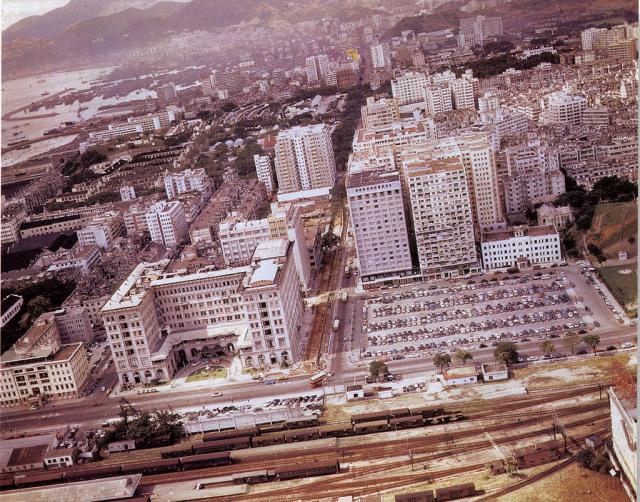
A good aerial view of TST, from longhaircheungmo's collection on Flickr.
Chungking Mansions and Mirador Mansions are both looking very bright & new. In fact almost everywhwre to the east of Nathan Road seems to have been re-developed - with the exception of an old residential building at the base of Signal Hill on the right of the photo.
It's worth viewing the large version of this photo, as there's lots to see.


Comments
tst 60s
mid 60s indeed. however neither mirador nor chunking mans are featured (apart from their rooftops). the 3 buildings in front of the car park are: ambassador hotel, far-east mansions and the cable and wireless building.
the car park is location of the current sheraton hotel (built 71/2).
behind the peninsula is the marco polo peninsula court where the late clavell lived on and off as he completed his asian sagas with hk bank underneath.
the tall white building on the left up nathan road is the president hotel (later hyatt) inaugurated in 1962/3
re: tst 60s
Anonymous, thanks for the extra information. Based on your dates for the opening of the president / hyatt, maybe this photo was closer to 1960 than 1965?
The Hyatt was roughly opposite the Mirador, but in the photo that place just looks like an empty plot. If we could see more detail, I think we'd see the empty plot is the construction site where the President was being built.
It looks as though Nathan Road is undergoing some major roadworks too.
Here's a good view of the area a couple of years later, after the hotel was built.
Re: TST 1960s
I tend to think the photo was taken in either 1961 (completion date of the Chungking Mansions) or early 1962. The President Hotel and the Sands Theatre (completion date 1963) on Peking Rd are yet to be built.
Dwarfed behind the Marco Polo/Peninsula Court. I think was the Star Hotel on the corner of Nathan and Peking Roads. Cheers.
Re: TST 1960s
Junction of Nathan and Salisbury Roads
In the top photograph. the traffic pagoda and policeman directing traffic have disappeared.
No sign of the Hotel Merlin
No sign of the Hotel Merlin yet, which should have been visible above the Peninsula. I don't know when the Merlin was completed, but it was there in 1964.
TST in mid 1960s.
The "old residential building at the base of Signal Hill on the right of the photo" is presumably the four storey building at the end of Middle Road? It was built originally as an hotel, was at some stage taken over by the army and used as some sort of headquarters, and eventually housed the Resettlement Department in the 1970s.
Re: TST in mid 1960s
I think when the above photo was taken, the building at the base of Signal Hill was used as the Hong Kong and Kowloon Garrison HQ.
re: TST in mid 1960s
Anonymous,
Thanks for the extra info about the white, four-storey building.
I meant the older building behind the top-right corner of that four-storey building. It's easier to see on this larger version of the photo.
Regards, David
Re: TST in mid 1960s
I think the older building behind the Garrison HQ was the Minden Row Junior School as seen: http://www.flickr.com/photos/donnyb-uk/4228183375/in/photostream
Older building
Thanks, David. Clearly the Minden Row Primary School.
Regards, Jabberjabber