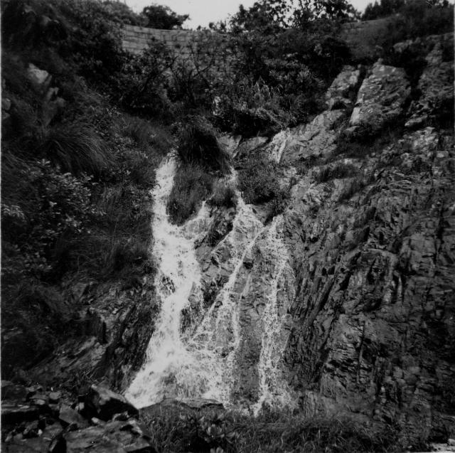
Another one from the Deep Water Bay page taken 23 May 1954. Underneath this my husband has written waterfall from roadway. Does anyone recognize it? Thanks to everyone for comments re the previous two from this page.
Pauline.

Another one from the Deep Water Bay page taken 23 May 1954. Underneath this my husband has written waterfall from roadway. Does anyone recognize it? Thanks to everyone for comments re the previous two from this page.
Pauline.
Comments
re: Waterfall
Sorry, another one I don't recognise. There's a wall up the top of the photo I can't work out. I'd guess it's a bridge, but it doesn't look right for that.
Hopefully Moddsey or T will recognise it.
Regards, David
Re: Waterfall
Thank you David, I know this is a tricky one but, like you I wonder if moddsey or T will come up with anything. There is no way of telling from how these photos are arranged on the page which comes first and which is last, there are a few more to come so perhaps they will provide more clues.
Regards, Pauline.
Waterfall Bay
I think this is WaterFall Bay in Wah Fu.
It is still pretty impressive, especially after a few days of solid rain. Here I am going for dip.
Re: Waterfall Bay?
Hi Craig,
I am uncertain. The two photos look similar however the rock formation did not add up. The series of photos by Pauline's hubby appeared to be taken along Lady Clementi's Ride. From 1:10,000 maps there are foot paths running parallel to the Ride. I wonder if the photo in question was taken on one such foot paths below the Ride at one of the streams. Note the retension wall behind the waterfall........
The trouble is that such paths are now in disuse and much overgrown. Need some efforts of bush whacking to find those paths. A bit difficult to find the present day location, I would say.
Best Regards,
T
Hi T. Your right, its not
Hi T.
Your right, its not 100%.
The other place it could be is, as you leave Repulse bay heading to Stanley, just before the little roundabout where you can turn to South Bay there is a Bus stop on your left. Right in there is stream, there used to be a little flower shop there a number of years ago. It could be there?
Re: Waterfall Bay...
Hi Craig,
I am still uncertain. However Pauline's hubby seemed to be shooting along the way. That particular trip appeared to be from the Barracks to Aberdeen. If Aberdeen was the destination, Stanley did not add up as well.
Actually the sort of retention wall look alike could be one of the stone bridges on the Ride. There are at least two between Wanchai Gap and the Catchwater. I'll try to walk along the ride again sometime next month and see how it goes.
Best Regards,
T
Righto, Here's my third and
Righto, Here's my third and final guess;
Is it the waterfall by the Aberdeen Technical Collage, next to the Ap lei Chau bridge?
Righto, Here's my third and
Righto, Here's my third and final guess;
Is it the waterfall by the Aberdeen Technical Collage, next to the Ap lei Chau bridge?
Aberdeen Waterfall
I'm not sure, Pauline's looks to be much steeper than the one in Aberdeen.
Re: Righto, Here's my third and final guess...
Hi Craig,
It seemed unlikely. There used to be a foot bridge running scross the stream/waterfall by the Aberdeen Technical College. The bridge collasped sometime in the mid 2000's during a rain storm. The photo in this thread did not have a bridge. The Aberdeen Technical College stream did not have the retension wall at the back either.
Despite the title mentioned it was taken near Deep Water Bay, I suspect it was somewhere up the slope. My argument is:
1. The Lady Clementi's Ride started a little bit below Wanchai Gap from Aberdeen Reservoir Road;
2. The Ride ended at Deep Water Bay Road. Remember, Nam Fung Road wasn't there yet back in the 1950's;
3. While studying the Map Search results at Hong Kong Map Service with the junction of Deep Water Bay Road & Nam Fung Road, there is a foot path following the catch water on the SE side of Deep Water Bay Road. The approximate location is 22.254217N 114.187816E This path runs approximately along the 130 contour towards the other side of the hill, till it reached the stream next to #4 Repulse Bay Road.
4. There is also another foot path running from that slope down to the Golf Course.
My speculation is that Pauline's hubby might have followed this path after he was done with the Ride and took that photo somewhere along the way. Unfortunatelly I do not have any idea where was the photo taken.
Best Regards,
T
Re: waterfall from roadway
Folks,
Please take a look of this street view. There is a stream under the Repulse Bay Road, which originated from Wong Nei Chung Reservoir. Down below the catch water mentioned previously started by this stream and goes back all the way to Upper Aberdeen Reservoir.
Could that stone work by the left be the same as what's been shown in the photo? I wonder....... Gotta go and take a look sometime. At least, it fits the description of 'Waterfall from roadway' of sort.
Best Regards,
T
Re Waterfall from roadway
Thanks to everyone for your thoughts on this. My feeling is that T is right as all of these seven photos on the Deep Water Bay page were taken on the same day and presumably all were taken on an expedition on foot. As I am sadly not familiar with Hong Kong I can't really help but if my husband says 'waterfall from roadway' then I'd take a bet that he was actually standing on a roadway looking up at this view.
Best Regards,
Pauline.