HKG 1960s Mike's photos
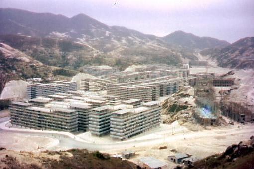
Kwun Tong Resettlement
Primary tabs

Submitted by mike
Gallery:
Connections:
- Kwun Tong Resettlement shows Place Kwun Tong Resettlement Estate / Kwun Tong (Tsui Ping Road) Estate [????- ]

HKG 1960s Mike's photos
Comments
Re: Sai Kung?
Hi there,
This wouldn't possibly be Sai Kung as there was never such a big housing development there. This photo might have been flipped and it is likely on the Kowloon Side. It doesn't click in my mind yet.
Best Regards,
T
Shek Kip Mei
Could be SKM? The mountain ridge line looks like the part that is west of Beacon hill. I'm thinking the road at the bottom could be Tai Hang Tung Rd and we are on the hill (that is still there) looking NW?
The photo Flipped, it was
The photo flipped, it was the Kwun Tong Resettlement Estate
http://www.uwants.com/viewthread.php?tid=15184666&page=13#pid205499998
http://www.uwants.com/viewthread.php?tid=15184666&page=2#pid196557059
Kwun Tong Resettlement Estate
Thanks for your help. I've flipped the photo and made a Place for this area.
Regards, David
Tsui Ping Road Estate
The location where this photo taken was Tsui Ping Road Estate. I was borne and brought up here. All were rebuilt into new type of public houses, accomodating much more people. My parent and sisters are still living there. Thank you British Colonial government built these simple boxes to accomodating us in past, providing us with basic means of livelihood that was very important to poor us in past.
Tsui Ping Road Resettlement Estate
Henry Ching writes:
I think this photo of the Tsui Ping Road Resettlement Estate (officially known as the Kwun Tong Estate) is looking towards the south or south-east. If my memory serves me right, the disastrous 1972 Sau Mau Ping landslide occurred in the area immediately to the left of (and off) the photo. There were more fatalities than in the Po Shan Road disaster that occurred at the same time. The victims were not living in the estate, but were in a licensed cottage area adjacent to the estate which was completely buried by the landslide.