HKG 1960s Mike's photos
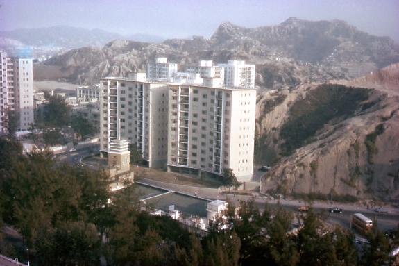
Argyle Street-CLP building
Primary tabs

Submitted by mike
Date picture taken (may be approximate):
Monday, January 1, 1968
Gallery:
Connections:
- Argyle Street-CLP building shows Place Nairn House [1957- ]
- Argyle Street-CLP building shows Place China Light and Power - CLP [1940- ]


Comments
Nairn House
The high-rise buildings opposite CLP's Head Office are Nairn House which were/are government staff quarters. Very spacious and airy inside from recollections visiting friends who lived there. The road alongside off Argyle Street was Nairn Road now known as Princess Margaret Road. The ambience of these apartments was destroyed when the Argyle Street and Princess Margaret Road flyovers were built directly in front and to the side of them. Who was Nairn to have a road and buildings named after him?
Re: Nairn
Sad to say that the western
Sad to say that the western portion fo the CLP HQ (to the right of the clock tower in the photo) is now being demolished to make way for (surprise!!) another residential high-rise. The clock tower and that section of the HQ will be preserved and proposed to house a showroom telling CLP's history.
Nairn House
Hi MikeSorry to trouble
Hi Mike
Sorry to trouble with you, however.... can we have the chance to get a more HIGH resolution one for our memories...., during it just have few photo for the waterloo hill.
Thank for for your share
Nairn Road
Hi Mike,
I saw your photo of Nairn House which was taken in 1968, right?
I wonder whether you were there in 1964?
It is a serious research I am doing. I am a founder of www.look4mama.com . I am helping my friends who are adoptees and were abandoned during 1950s - 1960s in Hong Kong, to look for their birth mother/family.
I am helping hundreds of them and trying to track down some roots for them.
One of the girls who was found on the hillside of Nairn Road at 6:45am on 13 Dec 1964.
I guess the hillside of Nairn Road would be Waterloo Road hill now.
I saw someone's comment saying he used to live in Nairn House.
May I ask that person whether he remembers anything around that area in 1964, please?
Was there a squarter huts area on the hillside or other side of Nairn Road when he used to live there?
Anymore information about that area of Nairn Road would be great, please!
Thanks.
Nairn Road is the old name
Nairn Road is the old name for today's Princess Margaret Road:
Nairn Road, which stretched northward (in the middle of King’s Park and Homantin resettlement areas) to the intersection of Waterloo Road and Argyle Street, was widened to become a major route, connecting Chatham Road to areas north of King’s Park and Homantin, and to Kowloon Tong. By the second half of the 1960s, Nairn Road was renamed Princess Margaret Road, and residents in the area settled in public housing elsewhere.
Page 181 of The Diaries of the Maryknoll Sisters in Hong Kong, 1921-1966
Re: Nairn Road
Renamed Princess Margaret Road after the royal visit in 1966. I was wrong to suggest the road was named after the CBF as the road system in the area was named after Scottish towns.
Princess Margaret Road was constructed in stages and completed in the early 1970s as indicated here
According to Wikipedia, Nairn
According to Wikipedia, Nairn road was named after a town in Scotland.