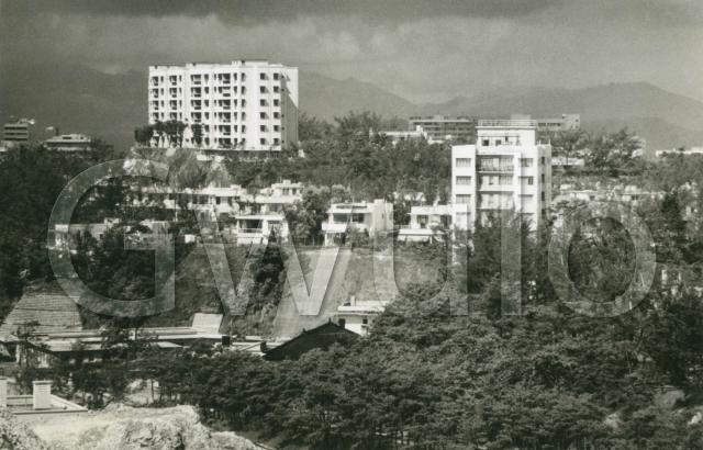
Who / What / Where: I'm hoping you can tell me! I don't recognise any of the buildings in this photo.
When: It looks like a stormy summer's day.
I bought this together with the recently posted photo of the HKFC stadium [1]. We dated that to 1963, so I guess this photo was also taken in the early 1960s.
Regards, David
References:
Reference: A243A


Comments
Kadoorie Hill
I reckon this is looking NW from Argyle St area over Kadoorie Hill. The building on the left could be St George's Court. Not many places with houses around a block like that.
re: Kadoorie Hill
Agree with Phil; was wandering around there last weekend. The old estate management office still has the original model of the whole development by the front door, as seen here:
http://www.thekadoorieestate.com/about/history/
1960s unknown location posted 9/8/13
My first inclination was that it looked like the lower end of Blue Pool Rd, Happy Valley as I remember it.
Geoff W.
Unknown location
I think Phil is right... it is St.George's Court.I used to live there.
Mike
St. George's Court
Thanks for the help identifying this one. I've made a Place for the building and added it.
Below the "W" of the watermark there's a building with a dark, sloping roof. I wondered if that was anything interesting. Does anyone know what it was?
Regards, David
Kowloon Hospital
David - given the angle on St GEorges building and assuming the picture hasn't been flipped - I suspect it is the roof to one of the buildings in Kowloon Hospital.
It could be the building that is currently marked as Central Kowloon Clinic on Google maps?
https://maps.google.com/?ll=22.322172,114.179956&spn=0.001377,0.001296&t...
Cheers
Phil
Re: Kowloon Hospital
When David mentioned the sloping roof, I tend to agree with Philk that it is one of the buildings in the grounds of Kowloon Hospital. Perhaps this reverse view as shown here
Location
Phil & Moddsey, thanks for the extra views.
Looking at the maps some more, the taller building behind the "l" of the watermark looks to be at 33 Kadoorie Ave, ccurrently a building site.
I think that puts us a bit further west than the Central Kowloon Clinic, but then I can't see a pitched roof that would match.
Another curious thing in the photo is that rocky outcrop in the bottom left of the corner. Any ideas?
Regards, David
Location
I think the taller building above the I, is what is now St.Georges Apartments located below Braga Circuit on Princess Margarett Road.
33 Kadoorie was a bungalow, I lived across from it at 28 Kadoorie Ave, which can be seen in the photo. [it is located within the G, above the ripwrap wall].
Michael
Re: Location
That section of road below Kadoorie Hill is technically Waterloo Road. I think Fivestar is correct in that the taller buidling on the right as being the original St. George Apartments.
Given the elevation of the photographer, would he/she be standing near Mandarin Court?
Kowloon CLinic
I don't think we are further west than Kowloon Clinic. Look carefully below the "G" and you will see some single storey buildings with flat roofs - these match with the single storey clinic buildings (the Kowloon Chest Clinic) that sit next to the previously mentioned Central clinic, on the corner of Waterloo and Argyle.
The angle on the roof of the clinic would put us somewhere around the east end of today's Baldwin Court (or whatever its 1960's predecessor was) and the height suggest it was taken from an apartment window.
Re: Kowloon Clinic
Hi there,
I think Phil got it right. if you draw a line along the middle roof topand extend it towards present day Baldwin Court it would likely show where was the photographc standing.
Checked up some Real Estate site and found the present day Baldwin Court was inaugurated in December 1976.
Best Regards,
T
re" Kowloon Hospital
seen here in 1930/2001 comparison. Eu mansions are in foreground of 1930 picture
http://goo.gl/pBlTPw
St Georges Apartments
As a matter of interest were St. Georges Apartments as shown in the photo, originally owned by Kadoorie Estates as were St Georges Court and St Georges Mansions?
The reason I ask is that I can find no mention of them in the Kadoorie Estate history.
re: Kowloon Clinic
I'd convinced myself that the low-rise buildings along the top of the watermark were on Kadoorie Avenue, but from your explanations should they be Braga Circuit instead? If so, is #4 Braga Circuit visible? We've got a Place for it and I'll add it in if it is.
Thanks for setting me straight,
Regards, David
Braga Circuit
The houses to the left of St Georges Apartments are in Braga Circuit, but if I recall correctly #4 was behind the houses which can be seen.