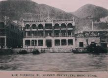
Seamen's Institute / Mission to Seamen building, Wanchai [1910-1962]
Primary tabs
Stephen Davies writes:
I am writing the 150th anniversary history of the Sailor's Home and Mission to Seafarers in HK, at the behest of the Mission here, and would very much welcome permission to use (and a high res image please) any images of the early mission buidlings. I am particularly interested in finding an image of the premises of the mission from 1910-1933, which were situated at 21 Praya East (post 1922 reclamation 18 Johnson Road). Post 1933 until around the mid-1950s these old Mission premises became a government building partly occupied by the PWD.


Comments
There is a good photo of
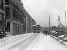
There is a good photo of Praya East from about 1915 in FormAsia's book "Once Upon A Time". In the second edition, it is on pages 90 - 91.
Regards, David
ML 295
The "Ordinance to provide for the Incorporation of the Missions to Seamen in Hongkong", dated 30th May 1919, places the building at "Marine Lot Lot No. 295", see: http://hkgro.lib.hku.hk/archive/files/ec339f8014d8a4e10d082a00b8dfdef2.pdf
Possible photo
On page 55 of the book "The Hong Kong Album" is a photo titled "View of Wan Chai District from the harbour about 1890" which shows this section of the Praya. The photos are from the Museum of History's collection, and they give the reference "P81.13".
Regards, David
Seamen's Institute, etc.
Dear David and others,
Than you so much for your help. I shall chase up the references. At present I'm embroiled in newspapers (the MMIS system is teeth itching, especially that one cannot copy pages but has to scribble out by hand).
I have now learned that the second permanent Missions to Seamen premises on HK-side was at 72 & 73 Praya East, buildings owned by the HK Land Investment Co, until a vacant site for building was lined up on part of Marine Lot 29, that got the address 21 Praya East (on the corner of Gresson St. and Praya East). I am not as familiar as most of you are with the PRO maps, and would welcome guidance on what to look for to tie down the exact location of the 72 & 73 Praya East site.
Thanks much.
Stephen D
Second Missions to Seamen premises
Hi Stephen,
Roads get re-numbered, which has tripped us up in the past. Please do you know which years it was at 72 & 73 Praya East?
Or if you can tell us the Lot number for that piece of land, that is a more reliable way to identify its location.
Regards, David
Seamen's Institute, etc.
David,
I am afraid I do not know any lot numbers. I know the address numbers - 72 and 73 Praya East. I also know that both buildings were owned by the Hong Kong Land Investment Co. I know that the initial lease was for 3 years and that it began in 1905. It must have been renewed because the Institute stayed there until 1910 when it moved to its new premises.
That introduces another puzzle. The new premises - address 21 Praya East - was said to be on Marine Lot 29 when it is first written about in the press and mission archives. Yet as you have noted (I already had a copy), when the incorporation ordinance was passed in 1919, the lot has transmogrified into Marine Lot 295. I am assuming this must have been a sub-division? Certainly on an early map there were two lots more or less where the new building was, numbered 29A (western lot) and 29 (eastern lot). From what I have learned, before the building was put up, part of ML29 (the easternmost of the two '29' lots) was nipped off to extend Gresson St to Praya East. The result was that the new Seamen's Institute was on a corner lot - though whether the eastern or western corner of Gresson St and Praya East I am not sure.
All and any help or clarification very welcome.
Stephen
72 and 73 Praya East
I've made a Place page for them:
http://gwulo.com/node/18701
ML 29 / 295
Yes, I think ML295 came into existence when the original lot ML29 was spilt up into smaller lots.
An 1889 map (Plate 3-2, Mapping Hong Kong) shows that ML29 was a long, thin lot running from the Praya back to Queen's Road. At that time, there weren't as many north-south roads connecting the Praya and Queen's Road.
Regards, David
Seamen's Institute
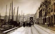
I've just found this photo of the old Praya. If you zoom in on the nearest building you can see the letters "Seamen's Institute" along the top of the building. It was on the north-west corner of the Gresson Street / Praya junction.
Wanchai Institute
David,
The colour picture is wonderful and I wonder if it is possible for the Missions to Seamen to have a hi res copy for the book (which is being published by HK City U Press). I have an original architectural line drawing of the facade and a very oblique, c.1922 image that is in the HKMH Moon Chu Foundation Collection. This is far and away the best image.
Stephen
re: Wanchai Institute
Stephen,
You'd need to contact HTWong on Flickr: https://www.flickr.com/photos/hoting2000/15598336071
I think the photos in his Flickr album are images that have previously appeared on eBay, ie he doesn't own the originals so can't give you any higher resolution copy than the one you see on Flickr. But worth checking to be sure.
You might also want to set up an alert on eBay for "Praya East" to notify you if any images of this area appear for sale.
Regards, David
Wanchai Institute
Thanks David, will do.
StephenD
Construction began in 1909
It is listed under "Works Commenced" in the PWD Annual Report for that year:
Seamen's Institute on M.L. 295, Praya East.
Construction completed in 1910
It is listed under "Works Completed" in the 1910 PWD Annual Report:
Seamen's Institute on M.L. 295, Praya East.
I've set 1910 as its completion date above.
Seamen's Institute
Thanks David. I have all of those details along with a (lo res) line drawing of the facade. It is extraordinary that the building stood until the mid-1960s (from 1930 to demolition as government offices), all up therefore for fifty years plus, yet so very few images of it seem to exist. The book looks like being published during the summer.
StephenD
Seamen's Institute
"yet so very few images of it seem to exist"
Yes, there's a huge difference in how many photos were taken of the seafront around Central, but so few of say Wanchai or Kennedy Town. I'm just writing up a photo of the 1902 Wanchai seafront for this week's newsletter.
I'll set the demolition date for this building to c.1964, as the next building on the site was completed in 1965.
demolition of old Seamen's Institute
Thanks David - my timeline gives the date of demolition as 1962 based on a statement to that effect in one of the Missions to Seamen's documents in the Hull Archive. That's could be either when the demolition began or, maybe, when the government moved out since I doubt it was actually referring to the first thump of a wrecking ball.
Stephen
Demolition of old Seamen's Institute
I concur with Stephen that the demolition probably started in 1962.
I bought an aerial photo of the area taken by the Lands Department on 1 February 1963 a while ago.
It clearly showed that the old Seamen's Institute had been completely demolished by then. There were some trucks inside the site, probably preparing for the construction of the next building - Everwin Mansion (嘉寧大廈)
Thanks, I've updated the
Thanks, I've updated the demolition date.
18th June 1910 Official opening
"18th inst.
This afternoon the new Seaman’s Institute at Wanchai, the gift of Sir Hormusjee N. Mody, was formally opened by His Excellency Sir Henry May, K.C.M.G., the Officer Administering the Government, in the presence of a large and representative gathering of Hongkong citizens…"
Source: The Hong Kong Telegraph Mail Supplement, page 208, 24th June 1910