Causeway Bay Camp [????-????]
Primary tabs
Submitted by Tymon Mellor on Wed, 2016-06-01 12:22
Current condition:
Demolished / No longer exists
Described in the 1950 Military Installations Closed Areas document as "Camp at the junction of Causeway Bay Road and Tung Lo Wan Road. Surrounded by a fence."


Comments
Location
The coordinates given in the document put the marker in the Chinese Rrecreation Club. I checked with Tymon, who says:
I assumed it was slightly north in the site of the recreation ground.
That makes sense, as the land was used as a recreation ground for the armed forces in the 1950s. I've moved the marker to there.
Another option is to follow the text instead, "at the junction of Causeway Bay Road and Tung Lo Wan Road". That would put it about where Queen's College is today. It could be possible that the school was built on the site of the land used for this camp.
Any extra information welcome.
Regards, David
Location of Causeway Bay Camp
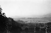
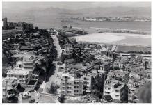
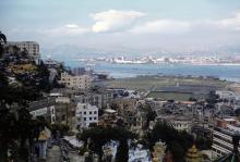
Some photos of Causeway Bay Camp surfaced on the Chinese-language forum Uwants recently. Please see Posts 3215 to 3219 here, and Post 3918 to 3920 here. Nissen huts were visible, and two posts in the second link gave the year as 1957.
It seems that the location of the camp was the present-day Causeway Bay (Moreton Terrace) Bus Terminal and the Moreton Terrace Playground behind the Central Library. The photo in Post 3218 of the first link seems to show the location of Fook Tak Temple on Tung Lo Wan Street. So, the camp was close to the west end of Tung Lo Wan Road (not the east end, where Queen's College is), and next to the Chinese Recreation Club.
When was the army camp demolished? I remember that the area was a scrapyard for a short time in the early 1980s.
Causeway Bay Camp
Hi There,
I think the site should include everything south of Causeway Road from the Nullah up to the corner of Morton Terrace. If they did not build the Central Library the fence would have gone that way, all around it till it reach Tung Lo Wan Road, up to where the Tai Hang Kai Fong Association (大坑坊众福利会) is. The CRCHK lot was granted in 1912 (according to their website) thus should be counted out.
I recall we used to call the site in the 1960\1970's as The Army's Playground.
T
Causeway Bay Camp
Hi tngan
I think you are quite right about the locations. I just found another photo that shows the entire area clearly:
So, the Causeway Bay Camp included the present-day Central Library, Moreton Terrace Playground, bus terminal and Tai Hang Residents' Welfare Association. However, the old football ground (now Causeway Bay Sports Ground) seems to have been called Navy Football Ground (I could be wrong). Since many local football league matches were played there, it would unlikely be part of a closed area. The Chinese Recreation Club was where the smaller patches of grass in different shades of grey were. They were and still are tennis courts.
Navy Sports Ground
Re: Army Football Ground....
Hi There,
That was just a remote impression. After all these years I began to doubt its accuracy. Anyway, despite the names I guess I at least I got the boundary of it about right. I vaguely remember there used to be some of those 'Halt when being addressed or your may be shot' warning signs at some locations along the fence,
T
Causeway Bay Camp
Thank you, tngan and moddsey, for sharing the important information.
Thanks for the extra
Thanks for the extra information and photos. I've moved the marker and added an outline based on your descriptions.
Scrapyard
C; I’m not sure what you mean when you refer to a “scrapyard” in the early 80’s. I wonder if you are referring to the Moreton Terrace Vehicle Pound? This was an area where vehicles which had been involved in traffic accidents, or had been impounded by the Police for some reason, were stored.
it came under the control of the Royal Hong Kong Police Traffic Division for HK Island. It was certainly in use in the late 1970’s and I guess into the early 1980’s, but I cannot tell you the exact year when the Police relinquished control over the site.
Moreton Terrace Vehicle Pound
Hi Tideswell27,
Thank you for providing the additional information. I remembered seeing many damaged vehicles when I passed by Moreton Terrace as a kid back in the early 1980s, so I presumed it was a scrapyard. From memory it was towards the southern end of Moreton Terrace (where the temporary playground is now), whereas the northern end (where the Central Library is now) was where a playground was.
Photo of the camp