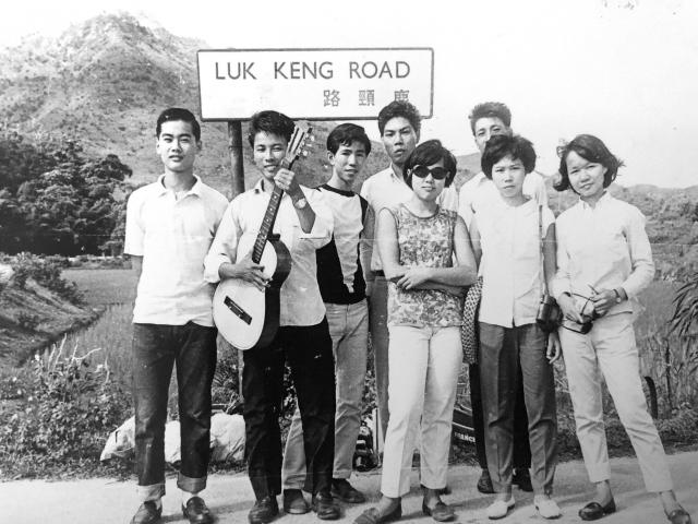
I came across this old photo belonging to my father. In the background there is road sign 'Luk Keng Road'. Do you know if this is in Luk Keng village and whether or not this road still exist? I am struggling to find much about this road on the net.
Get Gwulo's books
Directory
Click on your area of interest to choose from over 30,000 pages about old Hong Kong:
- Images & photos
- View - View galleries - View new - Create - Forum topics
- View - Create - Places & buildings
- View map - View new - Create - Streets
- View map - View new - Create - People
- View - View new - Create - Organisations
- View all - View new - Create - Diaries & memoirs
- View - View new - Create diary - Create page - Events
- View - View new - Create - Jurors lists
- View - Type a page
Or choose a popular article:


Comments
Luk Keng Road
I believe this was most likely taken at the northern entrance to Luk keng Road, near to the junction with Sha Tau Kok Road. The reason is because the hill in the background closely matches the one seen in Google earth here:
What I'm not sure about is the exact location..perhaps closer to where the road makes a slight turn SSE about 100metres in from the Sha Tau Kok Road entrance?
Luk Keng Road
Thank you very much. That is a very useful information to know. I am hoping to visit Hong Kong this year so I will make a trip to Sha Tau Kok as I would like to visit places where my father grew up.
I sent the picture to a few
I sent the picture to a few community members who still live in Pok Tau Ha, Nam Chung, and Luk Keng. According to a Mr Lee who was born in the late 1960s the road sign could only be found on both ends of the road but not in the middle. Very probably this picture was either taken at the junction of Sha Tau Kok Road and Luk Keng Road, or at what is now present day 陳鳳記 at Luk Keng.
@Karyum80 Just curious asking, is your father from Luk Keng Village or Nam Chung? Thanks!
Followup: on second thought it resembles the hill overlooking Wu Shek Kok. I think the first commenter was right
Luk Keng Village
Thank you for doing that. I appreciate all your effort in helping me. Whether or not my father is from Luk Keng Village I couldn't answer that question as I don't know the answer. However, I have found a document that states Chuk Yuin Village, Ta Ku Leng NT which would indicate to me that is where he lived.
Chuk Yuen Tsuen
It looks as though that area has been redeveloped, but the village is clearly shown on the 1952 map: https://gwulo.com/map-of-places#17/22.54829/114.15385/Satellite_by_Google-1952_All-Markers/100