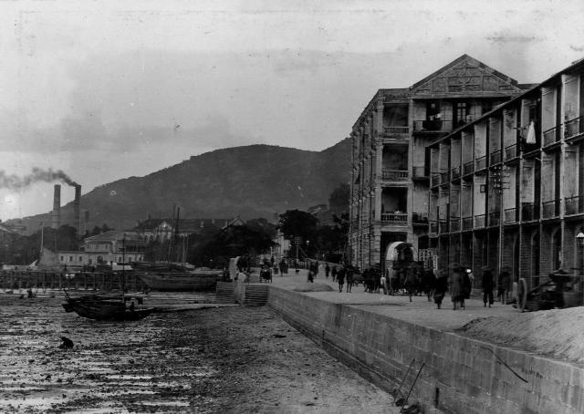
Hello,
That four storey house can be seen on many photos and postcards. Was that the Wan Chai Police building Nr.2 ? When was it demolished ?
Tahnk you very much for all your input

Hello,
That four storey house can be seen on many photos and postcards. Was that the Wan Chai Police building Nr.2 ? When was it demolished ?
Tahnk you very much for all your input
Comments
Sorry to say, but we have
Sorry to say, but we have this photo already. More information here.
Thank you Klaus for your
Thank you Klaus for your comment, I am still not sure what building the house was, on the left side with the triangle rooftop. That our storey building on the left looks like the former police building. Is that correct ? Just like to find out what building it was. Thank you very much for your reply.
Sorry, I meant to say the
Sorry, I meant to say the house on the right, NOT left. My apologies
Re: four storey house
Daniel, I do not know which building it was. I believe it stood just west of the Bowrington Canal on lot 270, visible on the 1905 map. It wasn't a police station, this was at (todays) junction of Leighton Road and Percival Street, it is also marked on the 1905 map. Regards, Klaus
Thank you very much for your
Thank you very much for your information Klaus. Have a good evening. Best regards
West of the canal.
If this was west of the canal then it could be the junction of Tin Lock Lane and Hennessy Road? Percival Street is to the east of the canal and Leighton Hill Road was never at the waterfront. Thanks!
Re: west of the canal
Hi maidestone, this is a misunderstanding. The photo was taken at the junction of Tin Lock Lane and Hennessy Roads (see here). The building with the triangle roof stood on Hennessy Road between Canal and Bowrington Roads.
It is neither No.1 Police Station (which stood on Leighton Hill Road) nor No. 2 Police Station (which was at Johnston Road).
Re: west of the canal
Greetings, Klaus!
Thank you for clearing up the matter. I did misunderstand your comment.
Cheers!