Pok Fu Lam PB, Pok Fu Lam Reservoir [1940- ]
Primary tabs
Submitted by Rob on Fri, 2012-09-07 13:32
Current condition:
Ruin
Date Place completed:
1940-01-01
Year completed is: Approximate
Condition at last visit: Intact
Date of last visit: Dec-1994
Ref: ROB-00689
Other:


Comments
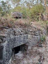
Inside the Pok Fu Lam pillbox
On Sunday I went for a walk with Rob, and he showed me a couple of sites around Pok Fu Lam.
First we came to see this pillbox. Rob remembers it being in good condition and with easy access. But looking at the "Date of last visit:" above, that was already twenty years ago!
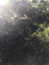
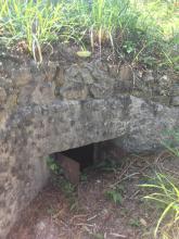
In the meantime it has had a large amount of earth dropped on top of it in an attempt to bury it. The entrance is now completely blocked, but someone has managed to dig out two of the three loopholes, and one of them is open. It's a bit of a squeeze, but I was able to wriggle in through the opening. Here's what it looks like inside:
How to access?
Hi guys,
I went to this area this past weekend. I know where the bunkers are and the military toilet block(right off the family trail), but I couldnt find this PB. I tried finding a trail from the family trail, as well as following those large pipes next to it and just crashing through brush in the estimated direction from the service reservoir.
Any memories/tips?
PFL PB
There are no direct paths, as far as I know. From the PFL reservoir roadway, go up the steps to the covered reservoir (shelters to right of steps).
Stand on western edge of reservoir near to where the steps stop, facing PFL Rd. Look downhill towards the buildings in front of you (University Quarters I think). Between you and them is a large patch of vegetation. The PB is in there, ROUGHLY in a direct line to the buildings. If you reach a fence you've gone too far. It is reasonably obvious once you get close.
Thanks Rob
Cheers! I will go back and see if I can squeeze into one of the loopholes and get some pictures.
Finally Found
Can't believe I missed it multiple times. It is only about 20 or so meters from the edge of the reservoir, on a slight plateau before there is a drop down towards the HKU buildings. In bushwacking a bit low trying to find the PB I stumbled upon a Japanese tunnel on the side of a ravine. https://gwulo.com/node/49548
Good stuff!
Distance from service reservoir?
1:is it where I circled?
2:Is there any picture of its outlook?
3:did you access from the HK Trail, along north west part of the high fence of the service reservoir?
4:is the tunnel further down the pipe where I have marked with an arrow?
Found at the location shown on GeoInfo.map
I used GPS and online map as mentioned above to locate it easily, it's just as shown in the place I circled last night.
However, after spending quite some time searching along the pipe and the valley with my friends, we still couldn't find the Japanese tunnel.
Due to the heavy rain before dawn, the place was still wet even with the sun above the tree canopy.
Good stuff. If you go again,
Good stuff. If you go again, the tunnel is on the opposite side of the ravine than the side the pipeline runs down, along the sloping section into the ravine.
Is it where my blue arrow
Is it where my blue arrow pointing towards?
Would you mark it on the Geoinfo map instead?
Your marker seems to be on the edge of the lawn when I check the satellite photo... Even the one for the pillbox is the same case, maybe the coordinates of the markers are not that exact.
It is opposite side as the
It is opposite side as the blue arrow, along the dashed line more like. Left side traverse along that ravine when going down. Mind, while the tunnel opens up inside It can only be accessed in prone position (wiggling in on your belly).
This location is really off,
This location is really off, PB is about 30 to 40m to the South, anybody knows how to correct this?
Only Rob or the administrator
Only Rob or the administrator have the right to adjust the marker.
I have been there after my previous posts, it's exactly at the place where I circled on the GeoInfo Map, but I was unable to locate the Japanese tunnel nearby.
Pok Fu Lam PB
Please leave an adjusted Lat and Long and I will correct the position.
Oh in the dry season it's
Oh in the dry season it's impossible to miss, to the east 10 to 15m down the slope. Nothing much to see though, all silted up. Just a tiny opening.
The GeoInfo map screenshot
The GeoInfo map screenshot where the orange circle is located is correct. One of the tunnel entrances is 10 - 15m to the east down the slope.
Thanks MikeB.
Thanks MikeB.
No wonder I couldn't find the tunnel, we've been searching west of the PB, so it should be between the main path downhill and the PB?
Yeah, sorry for potential
Yeah, sorry for potential misdirection there due to the marker being off. The tunnel is very closeby, as Mike B said. It is mostly silted up but I did wriggle in for some photos when I found it. I would suspect there could be other entrances nearby though.