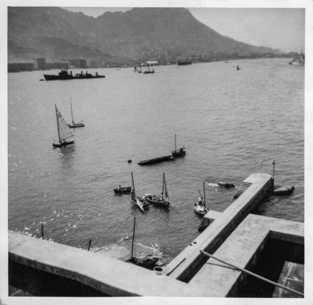
12. Yacht Club Quay (captured Japanese destroyer)
Primary tabs

Submitted by njkitto
Date picture taken (may be approximate):
Thursday, January 1, 1948
Gallery:
Connections:
- 12. Yacht Club Quay (captured Japanese destroyer) shows Place HMS Tamar Wreck site [1941-????]
- 12. Yacht Club Quay (captured Japanese destroyer) shows Place Kellett Island [????- ]


Comments
Surrendered Japanese destroyer. Tachibana class.
This is a gem of an image for those interested in warships Nicholas.
Patently not much detail to go on, but sufficient to identify the warship as one of the surrendered Japanese light destroyers of the Tachibana class, 14 which were completed in 1945 but whose service in those later months of the Pacific war are not well recorded. They were preceeded by the Matsu class but the fore mast differs which is useful for the id.
All Japanese warships destroyer size and below upon surrender were disarmed then divided equally between the UK, USA, USSR and China and the one here in the harbour is amongst the trio won by the UK which were sailed from Japan to Singapore with Japanese crews who were returned to Japan upon delivery. This occured in 1947.
I shall investigate further, she will be either the Hagi, Sumire or Kusunoki.
Sumire
Probably the Sumire as mentioned here
The masts from the wreck of
The masts from the wreck of the Tamar can be seen to the right of the destroyer in front of the white roofed building in Admiralty.
Hong Kong Yacht Club 1st generation
Hello everyone, I think this is the original yacht club from Electric Rd. & Oil St. in North Point and the original building is still on that corner today. The building in the bottom center of this photo is quite similar to the building of today, although the chimneys don't quite match, can ayone confirm this? The long pier maybe that of the Dutch Oil Co from that era as well. This screenshot came from a fabulous series of panoramas with exsquisit quality for enlargements and is the University of Cambridge digital library. http://cudl.lib.cam.ac.uk/view/PH-Y-30383-A/7
view from Kellett
hi this photo is taken from the roof of the Kellett Island Clubhouse looking towards the west (the waterfront part is where our Bistro Terrace is now)
the breakwater in the image is the one you can see here on Google Maps satellite view
below is photo taken today - it's as close as I can get to where the original photo was taken from as there is plant machinery on top of the roof now. you can compare the breakwater as well as the mountain in the distance
View from Kellett Island