Get Gwulo's books
Directory
Click on your area of interest to choose from over 30,000 pages about old Hong Kong:
- Images & photos
- View - View galleries - View new - Create - Forum topics
- View - Create - Places & buildings
- View map - View new - Create - Streets
- View map - View new - Create - People
- View - View new - Create - Organisations
- View all - View new - Create - Diaries & memoirs
- View - View new - Create diary - Create page - Events
- View - View new - Create - Jurors lists
- View - Type a page
Or choose a popular article:


Comments
Been there twice, still can't
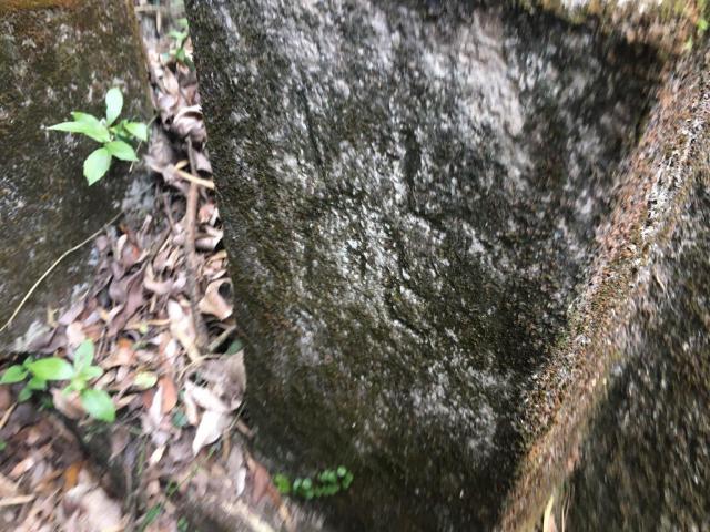
Been there twice, the stone is often covered with thick moss... still can't figure out if there is the number 38 inscribed on it. Can only read the letters AL 15(?).
On which side of the stone is the number 38?
It looks different from the #39 stone, are those stones having one side inscribed with the AL lot number, whereas the other side got the order number for this particular lot?
ADBS#38 how it come
** Please keep the boundary stone as original status as possible **
How we discover and identify ADBS# 38
- We found the 1905 ADMIRALTY boundary map of The Peak Sanatoria,
- According to the site plan then we located where is the lot.
- Then we overlay the map and plot the boundary on the 1963 Aerial Photos;
- Tranlate the coordinate of the boundary stone;
- Site visit according to the given coordinate and check if the boundary stone still in poisition;
- Use RTK GPS to record the coordinate of discoverd boundary stone ;
- check the discovered boundary stone coordinate and compare the 1905 ADMIRALTY boundary map;
- input the discovered boundary stone coordinate and infomation into our GIS system
According to the information on the map of The Peak Santoria and the coordinate of the boundary stones. We identify it is ADBS# 38 even the inscription is not clear.
Re: Old Maps and Boundary Stones
Thank you for finding and sharing the old lot layouts and aerial photographs. A very methodical approach and high tech way for locating the old boundary stones!
Thanks for the explanation.
Thanks for the explanation. You're fortunate to have access for all those equipments.
I'm not a fortunate Son
Dear H Lo,
these equipment and method was not borrow from other!I learn from zero and build and setup by My own! I'm not a fortunate Son!
https://www.youtube.com/watch?v=KD5_YJQzobs