Tai Tam Tunnel [1887- ]
Primary tabs
The Tai Tam Tunnel is one part of the Conduit from Tai Tam Reservoir to Albany [Filter Beds] [1887- ]. For more information about this early tap water project see here.
Tunnel works started in 1883 from both sides (Tai Tam and Wong Nai Chung), the technique applied was drill & blast (dynamite). Hard granite made the works pretty tough. Both sections met in mid-1887. The tunnel is 2,2 km long with a diameter of 1,5 m, it is unlined. [Source]
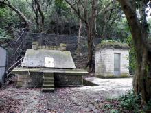
The inlet at Tai Tam is beneath the Recorder House. The location of the outlet on the northern side is unclear (to me). The 1885 map on hkmaps.hk shows it east of Wong Nai Chung Road, possibly near todays Marymound Secondary School. This implies that the conduit started further east and possibly ran along todays Blue Pool Road (sic!). The course of the tunnel was taken from the 1895 map at hkmaps.hk.
Update: the tunnel outlet is near the bend of Tai Hang Road, a bit further north than estimated earlier.
The tunnel likely still exists and is still in use.


Comments
Re: Tai Tam Tunnel
Hi Klaus,
I believe the tunnel may still be in used but not the conduit under Bowen Road. If you use Street View, there is sign post and an information plate, If you use GeoInfo Map or the My Map mobile App, there is an odd shape structure with a building and a bridge.
Many decades ago a plant (Eastern Water Treatment Works) was built in Wong Nei Chung Gap (37 Stubbs Rd, Happy Valley) right at the runabout. I believe the conduilt had been diverted there for water treatment before re-distributing to service reservoirs in the area. There is a service reservoir just next door for the Happy Valley area.
T
Re: tunnel outlet
Hi T,
thank you for this information. I also found the location on hkmaps.hk on the 1903.1 map. To make things a bit more complicated, there is another tunnel. It's the Braemar Hill Main Gas Tunnel from 1994, this is the one that is visible from the street, the Tai Tam Water Tunnel is likely behind it.
Next time when I'm in Hong Kong I will make a walk to this place.
Regards, Klaus
Tunnel dimensions
The Surveyor-General's Report on the Tytam Water-works (Public Works Department), 1 Nov 1885, p.104 - "The tunnel in course of construction from Tytam to Wong-nei-Chung for the passage of the waters from the new reservoir to the northern side of the island will be when completed, about 7,300 feet long or roughly speaking, a little under a mile and a third. It is six feet wide and seven feet high from the floor to the crown of the arch, these being the least admissible dimensions consistent with convenience of working."
There are further details given on p104-105 of the Report about the progress being made in the tunnel's construction, and the expected completion date.
(this information is also provided on the other page for the Tai Tam conduit (https://gwulo.com/node/51889) but it may be useful to have it here too)
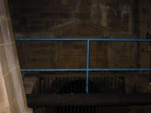
Here's a photo of the tunnel
Here's a photo of the tunnel outlet at the Wong Nai Chung Gap.
TyTam tunnel work progress - speed of boring
This ties in with LizB's post:
"Those of our readers interested in the progress of the new Waterworks at Tytam will be glad to know that, in consequence of the increased speed of the new boring machines, the tunnel is now being pushed on at the average rate of 160 feet per month, and it is anticpated that by the end of the year, one half of the tunnel will have been bored. The work on the Tytam Dam has been progressing slowly owing to the constant interruptions by wet weather. Work on the Conduit is proceeding steadily."
Source: Hong Kong Daily Press, page 2, 11th August 1885