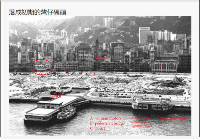
wanchai waterfront 1970.png
Primary tabs

Submitted by simtang
Connections:
- wanchai waterfront 1970.png shows Place Wanchai Ferry Pier (2nd generation) [1968-2014]
- wanchai waterfront 1970.png shows Place Gilman Motors Garage, Gloucester Road [????- ]
- wanchai waterfront 1970.png shows Place Wanchai Police Station, Gloucester Road [1932- ]
- wanchai waterfront 1970.png shows Place Harbour Hotel [1965-c.2005]
- wanchai waterfront 1970.png shows Place City Centre Building 城市大廈 (Asahi Pentax) [1966- ]
- wanchai waterfront 1970.png shows Place AIA Building, Stubbs Road [1967-c.2019]
- wanchai waterfront 1970.png shows Place Tung Shan Terrace [????- ]


Comments
Thanks for the photos you're
Thanks for the photos you're uploading. It'll be good if you can connect them to any key buildings that are shown, eg I've connected this photo to the page for the pier.
Here's how to add a connection: https://gwulo.com/node/37329
And here are the benefits: https://gwulo.com/comment/7483#comment-7483
Regards, David
relation not created
David:
I have updated the photo. I tried to add two more new places D="Asahi Pentax building" and F="harbour hotel". Got the error message "relation not created".
harbour hotel
The last building on the right next to the police station is F=Harbour hotel(華國酒店) at the Gloucester-Fleming junction. It was built in 1965, now is the Mormon church building (church of jesus christ of the latter-day saints).
.==================================================================
The building D has a sign "Asahi Pentax" on top. The relatively modern residential building city centre building 城市大廈 still exists today without the sign. Its year of occupancy was Sept 1966. By the way the 12 story small building at the center of the picture sanwiched between 2 old residential buildings is Lok Go Building 樂高大廈.. It still exists today. The year of occupancy was Oct 1969.
re: relation not created
The connection is between a photo and a 'Place' page. If you look at the map for that area (https://gwulo.com/map-of-places#17/22.27916/114.17524/Map_by_ESRI-Marker...) you'll see there aren't any Place pages (shown by the markers) for those buildings yet, which is why the error is shown.
If you'd still like to connect those buildings you can create their Place pages first by following these steps: https://gwulo.com/node/17628
date of photo later than 1968
A 1970 jan map shows that reclamation was still not complete yet. There was a large pool of water in front of the pier.
======================================
=====================================
The pedestrian bridge connecting Tonnochy road and the reclaimed land was built around Aug 1970 when the Gloucester road was widened. The photo likely was taken sometime in late1970 after august.
Thanks for the additional
Thanks for the additional detail. Please could you update the main title to match the correct year?