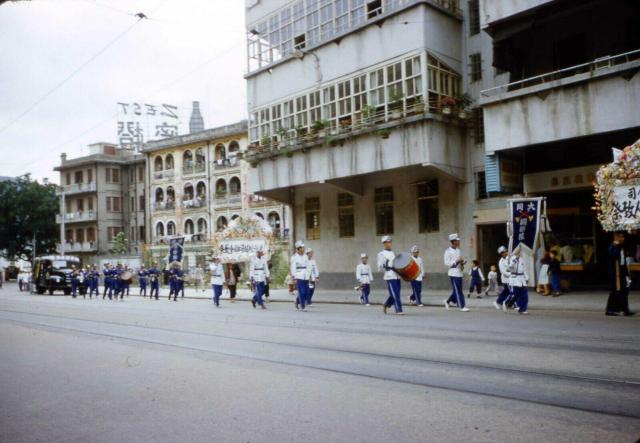
Am I correct with my assumption of Queens Way ?
parade_on_queensway_1955.jpg
Primary tabs

Submitted by danielwettling
Connections:
- parade_on_queensway_1955.jpg shows Place Junction of Yacht Street and King's Road [????- ]

Am I correct with my assumption of Queens Way ?
Comments
Re: Photo
Not sure f the photo shows the commencement of King's Road at the end of Causeway Bay But given the funeral parade, it may well be around Wong Nei Chong Road/Leighton Road.area.
Re: Photo
Hi There,
Uncertain exactly where was the photo taken, but there seems to be double tram tracks there, thus unlikely to be Leighton Road. Also based on the Chinese characters, the photo had not been flipped.
T
Parade
Greetings! That rooftop sign is about the same size as this, except the drink is different - https://gwulo.com/atom/20908
Were they at the same spot?
Re; Watson's Zest (橙蜜) Software Drink sign
Hi There,
I can only confirmed the neon sign in the photo was the Watson's Zest (橙蜜) Softdrink. Based on the tram tracks it is definitely close to the then Northern Shoreline of the Island.
T
Zest sign
There was a sign of Zest in the roof top of a building at the junction of Leighton road and Morrison Road. So this photo was taken from Morrison Road with Leighton Road in the left.
In Search of “Zest”
Here is the Zest sign for reference.
Re: Probably not the same neon sign
Hi There,
The Neon sign does not look the same. The bottle is on the right hand side of the word Zest on the top one (and no 屈臣氏)and this one it is on the left hand side with 屈臣氏 on the right hand side. The building look very similar, unable to confirm if it is the same building. If we throw in the double tram tracks.........
Totally disoriented now.
T
Parade/Procession 1955
Greetings! The two photos though taken 3 years apart might be showing the same sign, the latter was a new design.
The top photo (1955) shows clearly a single tram line, the other set closer to the building I am not sure - could be tire tracks. The top photo shows a tree, which would be difficult to find along the water's edge. The North Point police station site was a good location to attract viewers from the playground and race track. Regards, Peter
The photo was taken on Kings
The photo was taken on Kings Road at Yacht Street looking back towards Causeway Bay. The tree in the distance is approximately where entrance A1 of the Tin Hau MTR is today. The advertising sign is facing Victoria Park. Unfortunately I cant find any photos taken from Victoria Park showing the sign but the buildings match the 1949 aerial photo.
Here is the same view today.
Re: Unable to find photos of the Neon sign, but......
Hi There,
Found a photo at Uwants concerning Ngan Mok Street, which the buildings on the right hand side of the top photo here appeared to be a match. And the fenced off area too.
T
Re: King’s Road
My initial guess was King's Road near Ngan Mok Street but could not place the building behind with the arch openings. The funeral parade threw me off. The photo provided by T also appears on Gwulo here which was submitted some years ago.
Good job identifying the
Good job identifying the location!
Daniel, now we know the photo's location, please could you update the title.
Zest sign
This sign had bottle on the left in the earlier year. The enclosed photo is not so clear but should be enough to show the bottle was in the same position as that of danielwettling.