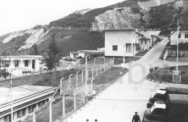
Two Bedford 3 tonners wait outside the Airmen's Mess ready to ferry personnel down town, or over to Shek O or sometimes Repulse Bay. Buildings shown are, bottom left part of the Tech block, mid left the Sergeants' Mess, top right the guard room and opposite it the sick quarters and nearer the camera the station headquarters. Perhaps the most interesting buildings are the two single storey ones in the centre and near the parked cars. In the 1950s one of them was the Accounts office but, more interestingly, they were the oldest buildings on the camp dating from before the war when they were part of an Army(?) Wireless station. Presumably, this was evacuated when Pill Box 37 at the Eastern entrance to the bay was also evacuated in December 1941 after being deamaged by shellfire.
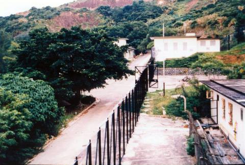
Thisnext photogaph was taken form the same window in 1987.


Comments
Was that a lamp post in the
Was that a lamp post in the centre of the picture, at the end of a high fence?
Was it of a similar design to the one at Mt. Austin?
Yes, it was a concrete lamp
Yes, it was a concrete lamp post. As both the Little Sai Wan camp and the path up to the Battys outpost were both constructed for the R.A.F., it is fairly certain that the specificication for all associated structures would comply with specifications laid down by the British Ministry of Defence.
It's lucky to have you being
It's lucky to have you being able to recall so much details.
Here's a link in which I believe such a post can be seen at the border of the small patch of open ground. Is it likely to be a lamp post or a radio post?
https://maps.app.goo.gl/QauwrTNcUUv5A1n69
I'm being told that someone has found 3 more along the same ridge ... somewhat further south of this one.
I'm wondering if there's another one not far from the path in the picture viewing from this angle (link as shown below), it's between the two modern lamp posts, but on the other side of the path, hiding among the dense vegetation ...
https://maps.app.goo.gl/jEPCXgitu1KPEyqm9
Been there on some dirt paths
Been there on some dirt paths along the ridge, came across 4 broken cement posts of which I am not sure if they were lamp post or radio masts.
I am fairly certain that
I am fairly certain that there were no lamp posts anywhere on the 'aerial farm' above and around the old R.A.F. camp at Little Sai Wan. Any maintenannce work to be done to the aeiral masts or the aerials themselves would have been done in daylight and the only people patrolling the closed area of the aerial farm in daylight or in the hours of darkeness would have been the R.A.F. policemen with their skilled dogs. They tended to follow a specific route, knew the terrain in detail and, with their torches, would not have needed street lighting. I have been thinking back to my visits between 2001 and 2007 and I recall seeing a few concrete posts just below the old camp road / Leaping Dragon Trail. By then they were heavily covered in climbing vegetation and I suspect that by now, even though up to about 5 metres tall, they are now entirely hidden. I have a feeling that they, and the ones that you have now seen, were part of a network that connected wires from the the aerials themselves to the communications centre. Somewhere, I believe that I have a photograph showing ceramic insulator(s) at the top of one of them, and I'll try to find it. One or two of the Gwulo contributors have taken photographs of these insulators that are occasionally found lying on the ground. Most of the actual masts supporting the aerials were very tall steel masts that looked a bit like small Eiffel Tours. You will see them on several of my photographs in the 367 Gallery.
For some unknown reason, I have not been able to access your two recent links relating to one of my photographs taken 'looking back to the camp gate. Certainly, the old camp had good street lighting and the lamp posts there were almost certainly to have been to the same War Department specification as those on the path up to the outstation on the Peak. There is one mast on that and other photographs taken around Little Sai Wan which is taller and thinner - and that was the flag pole. All military camps had flag poles, and flag raising and lowering each moring and evening were daily activities. This photograph shows the lower part of the lamp post outside the gate:
So those posts I came across
So those posts I came across up on the aerial farm are all aerial posts, while the one in your picture taken at the entrance down at Little Sai Wan is a lamp post.
That's a very concise description of the place, my sincere thanks to you for taking the time.
Here's a picture I took of one of the masts I came across. There's a slanted metal pole beside it, did it serve as another purpose?
The Google Maps links above
The Google Maps links above should be working now. (They had an extra space on the end that was upsetting our browsers.)
I cannot understand why two
I cannot understand why two poles would be so close together. A thought crosses my mind that one, perhaps the square cross sectioned one on the left of your photograph, might have been declared unsafe, or redundant and when the newer metal pole was erected they didn't bother to demolish the concrete one. It was certainly the case that, long after the camp had ceased to be a signals centre in about 1981, one could still see various metal and concrete poles still standing in the area of the old aerial farm. They would have had little scrap value and it would have been too much bother to have demolished them. In fact, on your(?) photograph taken from a drone, if you look more or less in the centre of the image - about half way down the slope from the Leaping Dragon Trail - you will see a distinct vertical bit of tall foliage sticking up above the main foliage. I suspect that it is indeed one of the poles, now covered with vegetation. I might try to pinpoint it but suspect that my computer skills are not up to it! However, I took a photo of the drone image, saw two possible poles and have inserted appropriate red circles around them. Perhaps a return visit by somebody might confirm things. I have just checked on a video that I filmed from the Cape Collinson road in 2005. It clearly shows the tall thin metal aerial mast ringed on this photograph, as well as several more.
Is this the same mast circled
Is this the same mast circled in your photo?
I cannot be sure but, if your
I cannot be sure but, if your photograph was taken from high up on the Leaping Dagon Trail (the old camp road), then it is probably the same one. The aerial erectors must have done a good job if the masts have survived nearly 70 years!
If you check on photographs taken by me and others in the 1950s, you will see that the hillside above the old camp was covererd in quite short grass. One day a friend, taking a short cut onto the Cape Collinson road, climbed from the camp up one of the stream beds at the western edge of the camp and found a lot of 0.303 rifle ammunition lying amongst the rocks. The military arrived and cleared it away and I believe that it must have been dumped by the soldiers who were retreating up onto the Cape Collinsion road when pill box 37, its lyon light and the nearby small wirelss unit in the bay were abandoned. That was on 19 December 1941 when Lt Scantlebury and his men retreated after the Japanese had shelled the area in order to prevent the lyon light illuminting their crossings at Lyemun. As the pill box, lyon light and wireless unit were almost certainly serviced from the sea, via a short stone jetty at what we knew as the Point (the stubs of its rusting metal posts show on the second photograph taken by me in 1957) retreat by sea was clearly not an option, and it is almost certain that the camp road was not built until during the time of the Japanese occupation or perhaps even until 1945, when it first appoears on an R.A.F. aerial photograph taken in 1945. So, the best escape route for Scantlebury and his men would have been up one of the gullies on the hillside and onto the Cape Collinson Road.
By 1957, a typhoon had caused PB 37 to collapse off its small rocky spur next to our firing range and it was dumped onto its side half buried on the shore. In early 1958 I saw it there but it was too deeply buried to be accessible. This photograph taken in 1957 from near the firing range shows the gully that my friend climbed up behind the building under construction on the right and also several of the metal aerial masts. The one on your photogaph is possibly the higher one of the two aligned 'above each other' just off centre on the photograph .
The stubs of 4 of the metal posts are visible at the bottom of this photograph with the bottom few steps of the pre-war steps up to the Lyon Light.
Thanks for the extra
Thanks for the extra information, here are the rough coordinates of the mast:
22.2591687, 114.2525343
So it looks like the type of aerial masts in the camp? The only question is we can't be sure if it's one of them.
I think that you can be sure
I think that you can be sure that any metal masts still present on the slopes above what was the Little Sai Wan bay are remnants from the old wireless station. Once the unit closed down, difficult access through the increasingly dense vegetation would mean that the masts and associated steel guy lines would not have had any real scrap value and there would have been no need to erect any new ones If you search through the photographs in the 367 Association gallery you will find that glimpses of many of the masts can be seen.
Mount Davis
Would RAF National Service personnel based at Mount Davis have worked at Little Sai Wan? This would be 1958. In particular, Brian or Terry Fowler, who were brothers?
Mt Davis personnel
Hi Paul,
For some years I was the historian for the late 367 Association - guys who mainly lived and worked at Little Sai Wan. The men who were based at Mt Davis (117 Signals Unit) worked there and not at Little Sai Wan, and I do not think that any personnel from Litttle Sai Wan worked at Mt Davis. A friend has an old school friend who lived and worked at Mt Davis, probably in 1957/8, and my friend will contact him to see whether he remembers Brian and Terry Fowler. The unit at Mt Davis was a small one and I should be surprised if there were more than about 50 men based there, so they would tend to know each other. I have a vague recollection that somebody once told me that occasionally the Mt Davis personnel joined with the Little Sai Wan personnel in inter forces swimming(?) teams - but I could be wrong. My friend will check with his friend, and one or both of them might wish to contact you but for data protection reasons any direct contact via emails would need to be cleared with the Gwulo webmaster. Best wishes, Andrew
Tall mast at Little Sai Wan - white with black base
Andrew,
Looking at the photos, I think the tall, thin mast is, in fact, the station flagpole from which would be flown the RAF colours. It appears to have a jib towards the top, which allowed the flag to stream freely without getting wrapped around the mast itself. It is positioned in a prominent central location, close to the 'Parade Ground'. What do you think?
Mount Davis
That's great , thanks Andrew.
David,
David,
No, the station flagpole was not very tall at all, and if you check on several of my other photographs you'll see that it was no taller than the SHQ building - nothing like as tall as the main accommodation block. All the currently still visible masts around the camp and on the aerial farm were either single pole metal aerial masts or shorter ones (often concrete) that carried cabling around the aerial farm. There are still a few of both dotted around the hillside but creepers have disguised many of them! Google Earth, Street View and some drone footage show how LSW looks now.