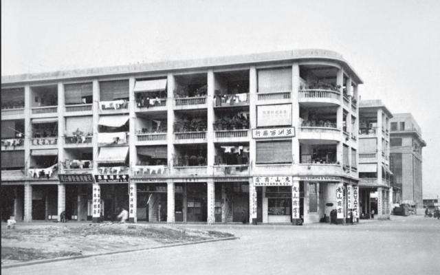
Source unknown. Construction of tenement blocks on the completed Praya East Reclamation. The Missions to Seamen has been erected but cannot view the China Fleet Club. In the foreground is the section of the waterfront between Luard Road and Fenwick Street. Circa early 1933.
1930s Fenwick Street
Primary tabs

Submitted by moddsey
Date picture taken (may be approximate):
Tuesday, January 1, 1935
Gallery:
Connections:
- 1930s Fenwick Street shows Place Sailors Home and Mission to Seamen / Harcourt House [1933-c.1983]
- 1930s Fenwick Street shows Street Fenwick Street [c.1928- ]


Comments
Might this be from a
Might this be from a different angle, so Fenwick Street running along the right edge of the photo, and the empty plot in the left foreground showing where the Chinese Methodist Church will be built?
Re: Location
Good observation. The key is Maruyama & Co etc unless there is corrobative evidence:
orientation
if you look at some of the aerial photos from 40s and 50s (e.g this one), the blocks were laid out parallel to the harbour, not perpendicular, so these ends were most likely facing a road running N/S rather than E/W. I think that the two blocks closer to the camera are actually located between Lockhart and Jaffe and the empty space might actually be the plot between Hennessy and Lockhart rather than the where the methodist church is? But I'm not sure, it could be just a trick of perspective. I can't tell if there is room for the other block between the middle and furthest.
Re: Orientation
Thanks for the inputs. Interesting photo to confirm the orientation of the roads. Gloucester Road vs Fenwick Street. On the to-do-list. If the orientation is north-south i.e Fenwick Street, I cannot figure out the building or structure behind the Missions to Seamen.
Re: Photo
Reviewed the original photo against the photo below. David and Phil are right. The photo is Fenwick Street looking north. As David says, the vacant plot of land is the Chinese Methodist Church. Will amend the title.