Get Gwulo's books
Directory
Click on your area of interest to choose from over 30,000 pages about old Hong Kong:
- Images & photos
- View - View galleries - View new - Create - Forum topics
- View - Create - Places & buildings
- View map - View new - Create - Streets
- View map - View new - Create - People
- View - View new - Create - Organisations
- View all - View new - Create - Diaries & memoirs
- View - View new - Create diary - Create page - Events
- View - View new - Create - Jurors lists
- View - Type a page
Or choose a popular article:
User login
Timeline
A timeline of Places at this site.
This:
- Wartime Cooking Area E, above Quarry Bay [????- ]


Comments
Book: Above Quarry Bay - The Eastern District Country Parks
Hi there,
A bi-lingual book called 'Above Quarry Bay - The Eastern District Country Parks' published by Friends of the Country Parks (ISBN 988-201-618-9) mentioned these, started with the Woodside.
Best Regards,
T
re: Book: Above Quarry Bay
Hi T, please does the book have any extra information about the stoves?
Thanks for the recommendation - sounds like you have a well-stocked library!
Regards, MrB
Book: Above Quarry bay
Dear Mr B,
I don't have this book. I just took a quick browse at a book store earlier. I have an impression that they have a few pages talking about the Woodside, as well as the stoves, with photos and quite a few paragraphs. Since I did not read it through I don't think I could quote anything for just a quick peep.
Book stores after Chinese New Year tend to offer discounts so if you want to acquite it it might be a bit cheaper. This being locas believe it would be bad luck to purchase books at New Year as the Cantonese pronounciation of the word book 書 is more or less the same as 輸, loosing, especially $$$ or a competition.
This is just one of these do's and don'ts during Lunar New Year.
Best Regards,
T
Communal Stoves
Hey boys, I have the book, I’ll copy the relevant material below.
“In October 1938, Guangzhou fell under Japanese occupation. Preparing for an imminent attack on Hong Kong by the Japanese, the Hong Kong government put in place various measures. These included preparing food rationing, heightening air raid precautions and first-aid training, and building air raid shelters in densely populated areas.
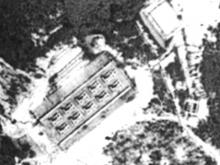
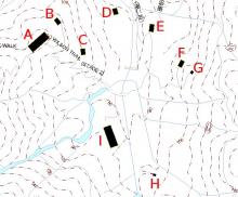
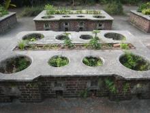
Today, on the northwest slopes of Mt Parker, within the boundaries of the Quarry Bat Country Park Extension, are four groups of outdoor stoves from this period still in existence . These are the only know ruins of communal stoves in HK. Not far from these stoves, caves (now sealed) can be found on the hillside. It is uncertain if these caves were connected with the communal stoves, or if they were built by the Japanese in anticipation of Allies recapture of HK in 1945.
In the 1930’s Shau Kei Wan was the most densely populated area in the Eastern District, and so several hillside air raid shelters were constructed prior to the outbreak of war. Now, after decades of landscaping and urban development, the shelter that once lied on the roadside are perched on steep slops.
HK fell into enemy hands in only eighteen days, The communal stoves never served their purpose. After the war, as part of the Eastern District was not seriously affected by urban development, the stoves remained. Today, they have become unusual memorials of the past.”
There are also a couple of photos showing the remains of the food stores which look like the “Toilet” someone found on Mt Parker, with trees growing through it.
War time cooking area
I was grew up from those hill side , I have ventured and camp in those stoves area (1956-1969), the cave that round the conner of the cooking area were air raid shelter, there were few more those caves , I had ventured inside some of them, those caves were not sealed at that time . The most easy way get to #1 Stoves and Cave follow the hike trail down from the Woodside House. Does anyone remember the shooting range for British soliders (1955-1965), a small stone hut by the side of the main water resvior , now had filled and build Korn Hill estate. The targets were place half mile up the water ducts above a sand pit on top of a small water resvior ( we called #3 resvior), everytime after soliders completed the shooting we climbed to the targets sand pits collected the lead and iron bullits and sold them to metal shops in Shau Kei Wan market. I was told there are tunnel near the path not far from General Rock connected with the North Point Revior, but I never have chance to investgate.
Thanks for the stories and photos. Sure bring back many happy memories. Wish I can go back to HK next year to see those Stoves and Caves again .
re: War time cooking area
Thanks for sharing your memories of this area. After you mentioned the rifle range, I looked at the 1952 map, and the words "Rifle Range" are shown between this marker and the Bungalow Dam reservoir:
https://gwulo.com/node/2837?a=1#16/22.2783/114.2149/Map_by_ESRI-1952_All...