Pillbox 019, Middle Bay [1939-????]
Primary tabs
Submitted by Unknown user (not verified) on Mon, 2008-07-21 13:05
Current condition:
Demolished / No longer exists
Date Place completed:
1939-01-01
Hi there,
I was walking from Repulse Bay to Deep Water Bay yesterday, taking pictures using my zoom lens. When I browse over one of those pointing towards Middle Bay I recognize a familiar feature right next to the swimming area boundary.
I'll send the photo in later for verification.
T


Comments
Pillbox 19
Hi T,
The wartime map shows there was a pillbox at Middle Bay. The location isn't exact, but it looks as though it was further south than where the shark net touches the coast. I've moved the marker south to the beach.
I walked along from the south end of the beach, along the beach and rocks until I reached the shark net again. I didn't see any sign of a pillbox. Does anyone know where the pillbox at Middle Bay was located?
MrB
Pillbox 19?
re: PB19?
It's frustrating we can't see more detail. There are definitely some small buildings there.
Rob's notes
Year completed is: Approximate
Condition at last visit: Demolished
Date of last visit: Feb-1997
Ref: ROB-00619
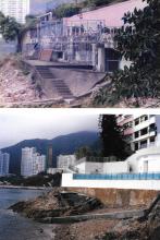
Other: The location is on the little headland where the swimming pool is shown in the satellite view. When I first found it, it had been converted into the pool pump room, but on a subsequent re-building of the estate, it had disappeared altogether.
PB & LL 19
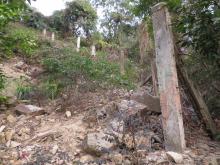
A portion of the perimeter fence that once protected PB & LL 19 is still there. Travelling along South Bay Road from Repulse Bay to Middle Bay, the last building on your right is No. 20-22 South Bay Road. Next to it a flight of concrete steps drop down the hillside to the sea. The wild undergrowth has been replaced by shrubs and trees, making the fence posts easy to see. They initially run in a straight line down the slope from the road.
Fence posts running down the slope from South Bay Road., by gw
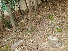
Half-way down they turn, cross the steps, and contour the slope to the wall of No. 20-22 South Bay Road.
Fence posts running across the slope., by gw
The posts are identical to those surrounding PB's & LL's 20 (www.gwulo.com/node/19380) and 30 (www.gwulo.com/node/1953). One of the posts still has remnants of the barbed wire fence attached.
Barbed wire attached to fence post., by gw
As at PB's 20 & 30, numerous small "r" shaped structures are present. They run in two lines, one on each side and parallel to the line of the fence.
Based on Rob's comment that PB 19 stood to the north of this area, this must be the southern part of the perimeter fence.
Thanks GW. I hadn't paid
Thanks GW. I hadn't paid attention to the fence-posts and "r" before, but I'll keep an eye out for them in future.
Regards, David
re fences
I think these are the standard barbed wire defenses. You also see them around Mount Nicholson, Jardine's Lookout etc. They also run alongside southside of Wong Nai Chung reservoir