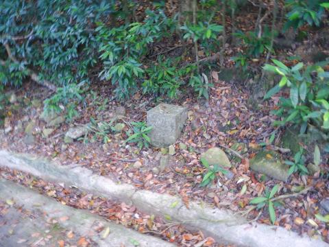
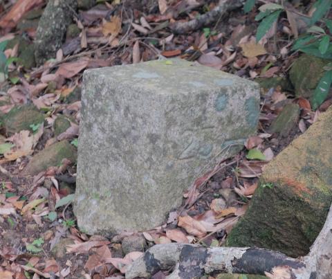
23 Marker Stone close to #7 Peel Rise [????- ]
Primary tabs
Submitted by tngan on Sun, 2009-08-30 01:31
Hi there,
I went up the Peel Rise on Saturday (29th Aug 2009) trying to locate the two stones. I found them. However when I pressed onward towards the peak I came across this stone. If you go up hill, it would be on your left hand side just about 30 metres before you reach #7 Peel Rise.
There are two sides engraved with the number 23. The two arrows are pointing to the same slope. I have been wonder why that was so. I don't see any engravings on the skyward side.
Best Regards,
T


Comments
re: 23 Marker Stone close to #7 Peel Rise
Well, that seems to contradict my idea that Peel Rise was 'route 25'. Did the arrows seem to point along paths, or just point at the hillside?
Regards, David
Re: 23 Marker Stone close to #7 Peel Rise
Hi there,
They are pointing to the hill side. I just checked a street map by Wanli found there is a mark of a foot path down Peel Rise towards the west, not far away from the stone. Maybe thes 23 stone was meant for that? The foot path, according to the map, goes towards the direction of Mount Kellett on the contour line of 350. I am uncertain if that means going around Mount Kellett or not. Unfortunately Google Maps doesn't show any of these.
I have a thought..... would the Matilda Hospital (or the military hospital before that) has anything to do with the stone?
Anyway I was unable to see any entrance of any path when I was there. I'll try again next time. Any there is a construction site up Mount Kellet Road with some demolition underway. The hammering could be heard down at the catch water.
BTW, the 29 marker stone I spotted was right on a junction.
Best Regards,
T
Re: 23 Marker Stone close to #7 Peel Rise
The Countryside Series map for HK Island shows the footpath from Peel Rise carries on around the hillside, until it meets the ridge leading down from the Matilda. The footpath along the countour is a broken line, meaning it may be overgrown. But the path down the ridge from the Matilda down to the HK Trail is a solid line, and should be more easy to see.
I still can't think of a good explanation for who marked these paths, and what they were used for.
Regards, David
Re: Path from Peel Rise going towards Mount Kellett
Hi there,
I just tried Google Earth and indeed, from the satalite photo a path is visible on the lower part of the ridge. Strange enough, I am not aware of that when I went along that section of the Hong Kong Trail. I was there last Saturday on my way back to Tien Wan. Maybe it's because my last few excursions there were done when it was getting dark. Now I know where to look I'll see if I could give it a try next time.
Oh there is one thing. The foot path seemed to be going extremely close to a construction site near the Matilda. After seeing the photo from Google Earth I was wondering if that section of the foot path is already blocked.
Best Regards,
T
Re: 23 Marker Stone close to #7 Peel Rise
Hi there,
I have purchased a 198X version (the oldest currently available) 1:10,000 map of part of Hong Kong Island from the survey & Mapping Office quite a few months ago and indeed, the foot path from Peel Rise extending to the ridge going down to the modern day Hong Kong Trail exists. It was a dotted line all the way, however.
These older maps takes about 10 days to be produced. They have 1:5,000 maps as well. You folks might like to check it out here. They have an index show you the pieces. A price list is also available.
Back in my school days I frequently use this series of maps for outings. These are not as compact as the countryside map, but it was good to learn Map reading on a larger piece. The new countryside map does have the advantage of water resistance, however.
Best Regards,
T
The footpath from Peel Rise
I walked down Peel Rise today, with the idea to walk along the dotted-line footpath. It should fork off from Peel Rise some way up the slope from the #23 stone, but I couldn't see any clear sign of the start. However, as I walked along, I could see what looked like a flat path up on the hillside, though not very clear.
A little way down the hill from stone #23 is a small culvert where water passes under the road. It is marked 'PL7'. On the left of the culvert there looked to be a path up the hill, so I took a scramble up there to look. In fact it seems the path was for workmen that had done some work up there. But once up the slope, it was clear where the dotted path should be.
There was a modern black iron water pipe, running flat along the hillside. Just next to it is what looks like a low wall, almost flush with the hillside. Perhaps an older pipe ran inside that wall?
It would be a scramble to follow their line along the hillside, but not impossible. I don't know if they still run as far as the ridge though.
Re: The footpath from Peel Rise
Hi there,
I had been thinking about going the other way round, about the solid line on the map down the ridge. But I have not made up my mind yet as for this season, we have to think about snakes as well as bees & wasp......... If a path had not been use for a very long time there are bound to be creatures lingering around.
I am not aware of any footpath going up from the pavilian at close to the end of the ridge down there, however my previous passing by of the pavilion was all in the early evening, before sundown. I would have to go in the morning or early afternoon next time and take a good look before making the decision.
Best Regards,
T
Re: The footpath from Peel Rise
Hi T,
Yes, I'm tempted to try the ridge path too. I think there's a slim chance to find any more of these marker stones, but I'd also like to look for the Artillery Observation Post, which Rob described as 'roughly 200 metres south of Matilda Hospital.'
I'm hoping it will be along the ridge line, making it easy to see.
Regards, David
Re: Roughly 200 metres south of Matilda Hospital.....
Hi there,
I wonder if we could locate a pre-war map showing the Hospital for comparison. I'd also like to know whether the hospital had expanded in the past few decades. The Hospital buildings up there now looked post war. If they have expanded the site limit towards the south the AOP might have already been destroyed.
Best Regards,
T
Re: Roughly 200 metres south of Matilda Hospital
Hi there,
I just compared the satalite photo of the current Google Earth with the printed copy of Hong Kong Guide 2004. There doesn't seem to be any changes if the Outline of the Hospital site is concerned. The Bangour (some villa to the East of the Matilda) had already disappeared in the current version of Google Earth.
Best Regards,
T
Re: Roughly 200 metres south of Matilda Hospital
T, I think we're still ok. The building roughly in the centre of the site should be pre-war. If I use Google Earth to draw 200m away from that, we're out in the clear on the hillside.
Regards, David