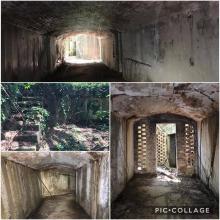
Pillbox 111, Hebe Knoll [1937- ]
Primary tabs
Submitted by Rob on Tue, 2012-12-18 21:47
Current condition:
Ruin
Date Place completed:
1937-01-01
Year completed is: Approximate
Condition at last visit: Ruin
Date of last visit: Jun-1995
Ref: ROB-00511
Other:


Comments
New coordinates
22.34947 114.24816
Is this tunnel related to PB111?
I think Rob might have stated
I think Rob might have stated somewhere else but that tunnel looks distinctively Japanese, could have been an alternate entrance tunnel they built (as with many other British defence structures). Any details on the tunnel? Location? Did you peak inside?
Hi oldhk~
Hi oldhk~
The coordinates of the tunnel are 22.34946 114.24818. Unfortunately I didn't bring a torch with me therefore I decided to re-visit the tunnel again after the summer.
How did you reach this PB,
How did you reach this PB, from Nam Pin Wai Village or Wo Mei?
Either from Nam Pin Wai or
Either from Nam Pin Wai or Mok Tse Che
There are adequate number of ribbons along the track
Any photos of the place where
Any photos of the place where you left the village for the dirt path?
Sorry I didn't take any
Sorry I didn't take any photos about the place
I can give you approximate coordinates of the places where you can go up the hill
From Mok Tse Che: 22.34656 114.24786 / 50Q KK 1654 7389
From Nam Pin Wai: 22.22.35121 114.24791 / 50Q KK 1655 7429
Any prominent features near
Any prominent features near the junction of the village road where you left for the path in the hill?
If you start from Mok Tse Che
If you start from Mok Tse Che, go across the river, turn right and walk for a few meters, you will notice a path on a "mud slope". Follow the path and eventually it will lead you to the entrance up to the hill. When you look inside from the entrance, you will see the ribbons.
If you start from Nam Pin Wai, once you go pass the public lavatory and walk up for about 50m, notice the path on your left hand side and there are ribbons next to the grave.
I will probably go there from
I will probably go there from PB110, hence, Mok Tse Che is likely to be my choice.
Is it to take the branch of the road towards the west, and then cross the last bridge at the upper stream, then turn right to look for the mud slope and the path further off?
The coordinates you gave me for this part indicated a field south of the bridge I just mentioned.
Yes should be the second
Yes should be the second bridge on upper stream near Hebe Knoll
Went up the dirt track behind
Went up the dirt track behind the village with new villas, followed a distinct path uphill, after passing the first grave, there seemed to be indistinct trail cutting directly towards PB111. However, this one led to a dead-end. So we re-trace back to the junction and went further up to a second grave.
Then descent on the other side only to find lots different colours of tags guiding us to PB111 and two small caves. We did not venture in for we're in a hurry ... we visited 7 PBs today, that's why.
wow 7? Did u visit PB121?
wow 7? Did u visit PB121?
Yes PB111 is located at the other ridge but at least its the shortest way after you visit PB110
btw, those caves are very short in distance and both with dead ends
Might have visited 121 with
Might have visited 121 with hiking groups before but not this time. Have to spend quite some time to check if I have been there, for they didn't mention the number to us at that time.
PB 121
PB 121 has a marker outside its entrance trench which makes identification easy. This concrete trench leads to a collapsed tunnel and the PB, which is the same shape as 122.
Thx for further info. But it
Thx for further info. But it seems that PB122 has disappeared...