Pillbox 200 a/b, Mau Tso Ngam [1937- ]
Primary tabs
Submitted by Rob on Wed, 2013-04-17 17:36
Current condition:
Ruin
Date Place completed:
1937-01-01
Year completed is: Approximate
Condition at last visit: Ruin
Date of last visit: Jan-2005
Ref: ROB-00527
Other:
Photos that show this place
 2020 |
 2020 |

")
Comments
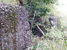
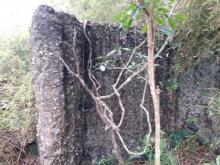
PB200a (1 loophole)
PB200a (1 loophole)
PB200b (2 loophole)
Should the pin be at a higher
Should the pin be at a higher ground than the present level shown on the map?
Is the present pin for a or b?
PB 200a/b
Can't give an exact answer to either question. The contour lines on the Gwulo map have no heights, so it becomes difficult to compare heights with my map. It is possible that all visual and mathematical conversions necessary to get a Lat/Long create an error. If you can give me an updated position from GPS I will happily change the position.
For PB's that have two parts I generally used a mid-point reference. I presume that is the case here.
Weren't able to locate the pb
Weren't able to locate the pb at the estimated location shown by the pin which is not too far from the path. There were tags leading uphill but I had only follow them uphill for some metres since I was rather exhausted as that was almost the last part of my trip. So I just left it for the next trip, and by the meantime, will try to get more details first.
200a KK 13736 75920 ~336m
The present pin is closer to 200b
200a KK 13736 75920 ~336m
200b KK 13708 75916 ~340m
Thanks. That's cool. Will try
Thanks, ck89. That's cool. Will try to look for them.
PB 200a/b
Thanks, but I need Lat and Long to change the position on the Gwulo map.
Coordinates in lag & long
200a - 22.36543 114.22028
200b - 22.36540 114.22001
Cheers~
PB 200a/b
Thanks. Position moved to your co-ordinates for PB 200a.