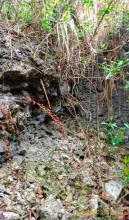
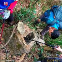
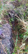
Pillbox 310, Shatin Heights [1937- ]
Primary tabs
Submitted by Rob on Wed, 2013-04-17 17:44
Current condition:
Ruin
Date Place completed:
1937-01-01
Year completed is: Approximate
Condition at last visit: Ruin
Date of last visit: Dec-1995
Ref: ROB-00560
Other:


Comments
Coordinates
Coordinates : 22.3659332 , 114.1651541
50QKK0805676081
PB 310
Thanks for all the coordinates. I have updated the positions of PB's 202, 203, 205, 206, 309 and 310 accordingly.
...
Better let someone double check in person, I can't say for sure that mine are 100% accurate, just hope it helps.
If the base map can be allowed to choose 2 types at a time, that will be much easier to find out the exact location on my app.
For instance, is it possible to choose both map ESRI and OSM as the base maps?