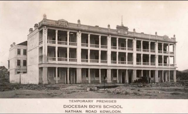
Thanks to Vanessa for this photo. She writes:
thought you might like to have this photo for gwulo. i have never seen it before, neither did i know that DBS had an interim campus between bonham road and argyle street.
I haven't seen this one before either - Nathan Road in the foreground looks like a country lane, with piles of rocks and weeds growing.
The AMO's notes have some more background:
Although completed in 1925, the Old Kowloon Police Headquarters was not occupied by the Police until 1932. From 1926 to 1932 it was used as temporary premises by the Diocesan Boy’s School (拔萃男書院).
I've guessed the date of the photo is 1926, based on the rough appearance of the road.


Comments
dbs- mkk police station
thanks for filling in that blank, david. the caption is incorrect then since nathan road (as we know it) was not yet built that far up town.
Coronation Road / Nathan Road
Hi Vanessa,
The road in the photo isn't much to look at, but it might have already been known as Nathan Road by 1926.
A 1924 map of Kowloon (plate 4-4, Mapping Hong Kong) shows Nathan Road to the south, but the northern section is named Coronation Road. This 1924 document (http://sunzi.lib.hku.hk/hkgro/view/g1924/87645.pdf) shows that the junction with Waterloo Road was the changeover point.
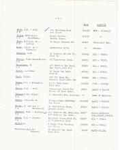
Then a 1926 document (http://sunzi.lib.hku.hk/hkgro/view/g1926/99620.pdf) lists the house numbers for the newly extended Nathan Road, which it describes as "Formerly Coronation Road". On the East Side of the road the last entries read:
Here is Argyle Street
674-700 Vacant land 14 Numbers K.I.L. 1262
Here is Fife Street
Mongkok Police Station
Here is Mong Kok Road
Crown land
So by 1926 it definitely ran as far as Mong Kok Road, which is only a stone's throw from the temporary DBS site. (The Mongkok Police Station in this list is further south than the temporary DBS site, see http://gwulo.com/node/19464).
Alternatively the photo & caption may just have been printed in later years when Nathan Road had already reached that site. Any idea when it was printed?
Regards, David
sorry, no clues as to when it
sorry, no clues as to when it was classified, david, or who wrote the caption - someone i know from school days sent me this scan. i lived on the argyle campus for 12 years way back when so was surprised to learn this little nugget of history!
good sleuthing on the topic of nathan road :)
DBS temporary premises
A correction to the dates, DBS were only in this building in 1927 & 1928, see: http://gwulo.com/comment/29790#comment-29790
Mongkok Police station
am I right in assuming that this building is the one that fronted Nathan Road between Argyle Street and Playing Field Road - in other words the block that was demolished to make way for Prince Edward Station in the...(70's)? It doesn't look like the current building that remains at Mongkok Police station (differrnt roof, arches at the bottom etc)
back of building?
Might the building that still remains on the Mongkok Police Station site today, be the one at the back of the DBS building in the photo? And as suggested by PhilK, the DBS building has since been demolished; this could possibly account for the current large gap between Nathan Road and the one still standing?
re: Mongkok Police station
Hi Phil, yes, that's the same building.
It was originally built as two rows of five houses. DBS used both rows when they moved here:
The School was temporary moved to "Ten Houses" (now Mongkok Police Station) in the corner of Nathan Road and Prince Edward Road.
From: http://www.dbs.edu.hk/aboutdbs/DBS_Brief_History.pdf
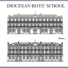
If you zoom in on the photo above you can see the the houses in each row look very similar, but the two rows' facades are quite different.
The front row faced west onto Nathan Road. It was the grander side, and had covered balconies on the first and second floors. This is the row that was demolished.
The back row faced east, and only had a covered balcony on the first floor. As Elizabeth notes, this row is still standing.
Richard Wong posted a good drawing of the two sides to Flickr:
Regards, David
Mongkok Police station
okay, many thanks. I hadn't realise these were built as rows of houses, I just assumed they were one large building and built as such.
mkk police station
great digging, guys! now i remember the building - it was bang on the corner of prince edward and nathan but the entrance was on prince edward.
my middle brother and friend once spent a whole saturday afternoon in their detention cells for *defacing government property*
(they were scratching their names on a litter bin whilst waiting for the 2C bus on yim po fong street to get to a cricket match at the KCC, a bus which, by all accounts, was taking forever). anyway a jeep drove by and a burly police officer jammed the brakes, crossed the street and hurled the pair into the back of the vehicle, kit and all!
not sure if my father was more angry with the zealous cop who held them until 6 o'clock, or the kids themselves since he and the other dad had to pay to repaint the litter bin - it was already in a state of degradation with multiple scratches and autographs, so, if a fine were to be given, he never forgave the policeman for not allowing them to go along to play the game - and deal with the consequences later. abuse of power or singled out for example??? never found out the score with the kgv team two key men down
expat kids from the 70s- we sometimes had questionable behaviours for sure!