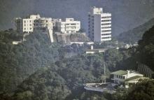
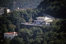
Commanders Residence (was "Headquarters House"), 11 Barker Road [c.1978- ]
Primary tabs
Submitted by David on Fri, 2015-05-29 14:51
Current condition:
In use
Date Place completed:
c.1978-01-01 (Year, Month, Day are approximate)
Not an easy one to get a photo of, as there's a PLA sentry on the entrance slope, and I never quite have the courage to point a camera in his direction.
Did it belong to the British Army before the handover?
Tags:
Photos that show this place
 1985 |
 1996 |
 |


Comments
Headquarter House, 11 Barker Road
That reminds me that the last time I walked passed this house down a path to either the next level or on down to Central, just as I was preparing to take a picture through a side gate next to the path, a PLA soldier appeared the other side.
I do not know who was more surprised, him or me!
Headquarters House
Pre 1st July 1997, the Commander of the British Forces ( CBF) stayed at Headquarters House on Barker Road. I recall going there for lunch pre 1997.Major-General Bryan Hawkins Dutton CB CBE (born 1 March 1943) was the last Commander of British Forces in Hong Kong, from 1994 to 1997.
Regards,
John Budge
re: Headquarters House
Thanks John. That means it would have been transferred to the PLA after the handover, and explains the sentry!
Regards, David
PLA SItes
re: PLA Sites
Thanks Phil, I'd forgotten that one. I've updated the building's name.
Regards, David
11 Barker Road
I ran by there yesterday and was surprised to see a PLA soldier with a machine gun guarding the entrance way. For a better view into the compound, best to walk up Llyod's Path up to Severn Road and look down. The razor wire looks pretty fresh on the perimeter, and the fencing looks like a recent addition (and twice the height of the older more modest fencing)
build date
do we know the build date for this house? wiki states it wasn't in use by the British garrison until 1978 and I have just been watching a film that shot a scene on the podium in 1976 showing a very empty site, so I am assuming the current house was built between 76/77.
re: build date
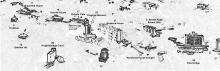
I took a look at the 1:1 000 Topographic Maps on HKMS and they have three maps from around that time:
But... the outline of the building on the 1985 map is exactly the same as on the 1979 map, so I'm not sure it really wasn't there in 1979.
aerial images
I looked at the online aerial images and the June 1977 images show it as a building site, but the December 1978 images show a completed building. There doesn't seem to be any images taken between those dates.