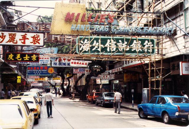
I believe that this was Middle Road looking West towards Nathan Road in the background. It might have been Mody Road. The twisted trees should provide a good clue! Correction it is Hanoi Road. I wonder if the twisted trees are still there. Thanks T.
Hanoi Road

Submitted by Andrew Suddaby
Date picture taken (may be approximate):
Tuesday, July 21, 1981
Gallery:
Connections:
- Hanoi Road shows Street Hanoi Road (was East Road) [1893- ]


Comments
Re: Hanoi Road
Hi There,
The Millie's Handbags & Shoes Manufactory Company gave the location. That was Hanoi Road .
Thanks & Best Regards,
T
Thanks T. I'll change the
Thanks T. I'll change the description. Andrew
Trees on Hanoi Road
Hi Andrew,
these trees can been seen on one of Mike Cussans' photos from 1970 and one mine from 1980:
When I posted mine I checked the location on Streetview - all trees are gone!
Regards Klaus
Hi Klaus, Being charitable,
Hi Klaus, Being charitable, perhaps the trees had reached an age when they had became too costly or difficult to maintain. Their removal is a shame as they made an otherwise 'standard' Kowloon street have that bit of extra character which made the street attractive. I wonder how long the similar trees down the Western side of Nathan Road will survive; although I have a feeling that I read somewhere that they had a preservation order on them - for what that is worth these days. Maybe their proximity to Kowloon Park helps. I have a very vague memory that in 1958 the Eastern side of Nathan Road had similar trees along the pavement but I might be wrong. The 'palm' trees along the central reservation there could have been planted to compensate for the eventual demise of the others, which are old enough to feature on at least one photograph that I have seen from the 1941-45 period. Regards Andrew
Re: Hanoi Road
Hi there,
I think they have planted a few new trees along the street some time ago, probably after K11 was completed. It is yet to be seen if those trees would survive the environment.
T
Hello T. What is K11? I hope
Hello T. What is K11? I hope the trees survive. Andrew
Re: K-11
Hi Andrew,
The K-11 is a redevelopment project which knocked down the whole block from Hanoi Road up to Bristol Avenue (except the Hiranand House owned by some Indian Merchant on Bristol) for a high rise, which also hosts the current version of the Hyatt Regency Hotel. The project also killed a street between Hanoi Road & Bristol Avenue which I have totally forgotten its name. I will update if I could retrieve the name somewhere, sometime.
T
Hello T
Hello T
Thanks. On one of my old maps (1981) the street running parallel to Hanoi Road and that was obliterated by the K11 development was called Cornwall Avenue. It joined Carnarvon Road with Mody Road.
Best wishes Andrew.
Trees on Hanoi Road
Hi All,
sometimes its helpful to use the timeline feature on Google Streetview. Hanoi Road from July 2009 looks like this:
At that time the old tree - or at least a part of it - is still there. Possibly too old to retain.
Next entry is from February 2011:
The old tree was cut down and replaced by a young one. On the other side of the road they planted trees, too. So tngan remembered correctly!
Andrew, I created a place for Hanoi Road [????- ]. You might add it to your image.
Regards, Klaus