金星門 - Cumsingmoon - Cum Sing Moon [????- ]
Primary tabs
Submitted by annelisec on Sun, 2016-05-22 05:38
Not to be confused with Cap Sing Moon
Both were where receievnig ships (opium hulks) were anchored.
Firms included
Jardine Matheson
Augustine Heard etc.
Later used for the (forced) international coolie trade (human trafficking)
http://gwulo.com/node/32405#10/22.3031/113.8685/Map_by_OSM-Markers/100
Tags:
Photos that show this place
 1840 |
 1858 |
 1858 |


Comments
Capsingmoon / Cumsingmoon
There were two harbours around there, one named Capsingmoon and one named Cumsingmoon. I guess the Chinese characters above are for Cumsingmoon.
This entry on page 427 of Alexander's East India and Colonial Magazine, Volume 9 from 1835 describes them:
On the 13th, we entered the Capsingmoon, a picturesque harbour, which is regarded as a safe place for ships; but, lately, many of the opium ships have left it for the Cumsingmoon, which some perons consider to be a still safer harbour. The Capsingmoon has some towering verdant mountains, with fertile valleys, and the small thatched cottages of fishermen and others peeping through a thicket of foliage: this is contrasted at another part by barren hills, destitute of any beauty, excepting what may be scantily imparted by a few stunted shrubs or ferns.
On the 14th, we sailed over to the Cumsingmoon harbour, And anchored there about sunset;—this harbour is formed by different islands and the main-land to the northward of Macao, and distant about eighteen miles from that settlement; it possesses far more extensive and picturesque beauties than the harbour we had left; however, the entrance is difficult and even dangerous for strangers; yet, after having been once, the same person could easily take a ship in or out any time without risk, taking advantage of the tides. From the land around this place not being so elevated as in the rival harbour, the gusts that descend from the gullies, in stormy weather, are not so violent; and, consequently, a ship is not so liable to drive, as has been experienced during some severe typhoons, which occurred a short time previous to our arrival.
I await placemarkers for
I await placemarkers for these. I posted to find someone who knows. The first character is Gum (gold). Gum Sing is Gold Star. The coolie trade was from the Venus Gate. I wait for enlightenment. So where exactly was Cap sing moon?
Capsingmoon
Capsingmoon may refer to Kap Shui Mun in Hong Kong waters near Ma Wan
Cap Sing Moon of Hong Kong?
Hi there,
A google search gave me these Australian pages: http://mariners.records.nsw.gov.au/1867/10/064cap.htm
[http://srwww.records.nsw.gov.au/indexes/searchhits_nocopy.aspx?table=Index to Vessels Arrived, 1837 - 1925&id=49&frm=1&query=[Ship Name]:cap sing moon] (May have to copy and paste this link to open it properly).
It says that Cap Sing Moon was the name of a Hong Kong ship that sailed from Foo Chow (Fuzhou) to Sydney in 1867 and again in 1868.
Another page http://findingaid.winterthur.org/html/HTML_Finding_Aids/COL0235.htm
down near the end within 'Folder 7' it says the ship Capsingmoon (with Captain E. Rosseter) was involved in 1833 with delivering Turkey opium.
Anyone fancy speculating the relationship between the vessel and the place of the same name?
[Edit: updated findings about Capsingmoon the place]
Using another spelling "Capsingmoon", I managed to find these page on Amazon: http://www.amazon.com/Narrative-voyages-services-Nemesis-illiam/dp/123130815X
Click 'Read more' and a passage from the book appears. Down near the bottom in what seems to be some sort of sub-headings, there is reference to 'Lintao' (can it be Lantau?) and 'Capsingmoon passage'.
This book, Narrative of the Voyages and Services of the Nemesis from 1840 to 1843, Second Edition, is downloadable at http://www.gutenberg.org/files/43669/43669-h/43669-h.htm#CHAPTER_XII
In Chapter 12, down on page 99, is a detailed description that Capsingmoon is on the northeast tip of Lantau Island:
'... In reality, the little peninsula of Macao on the west, and the island of Lintao (not to be confounded with Lintin) on the east, may be considered as the proper boundaries of the entrance to the Canton River.
These points are about fifteen to twenty miles apart, while between them lie several small islands, through which are the two principal navigable passages (the western and the Lintao passages) into the river itself. But the island of Lintao, called Tyho by the Chinese, is a long, narrow, mountainous piece of land, broken up into numerous bays and projecting points, stretching from south-west to north-east, separated at the latter extremity from the mainland only about the distance of a mile. The passage and anchorage between them is called Capsingmoon, and is made use of occasionally even by large vessels, which pass towards the river or across from Macao towards the island of Hong-Kong, which lies off the mainland at about five or six miles to the eastward of Lintao.[13]'
The footnote says see map, which appears at the end of the volume. The map gives a good illustration of the Pearl River Mouth with the old names, though it doesn't indicate Capsingmoon. The book also makes no mention of Cumsingmoon at all.
https://www.amazon.es/Supplement-1891-Professor-John-Ward/dp/1154991733
This one from 1891 mentions water boundaries, with a N-S line drawn across 'Capsingmoon Pass'.
breskvar
ship name
I guess any relationship would depend on whether the ship used the same Chinese characters as the place. It's hard to know once the name has been Anglicised.
A bit of extra information
Digging a bit deeper, I find this bit of information which I don't understand:
http://trove.nla.gov.au/newspaper/article/198923534
In 1874, printed in The Tasmanian, Launceston, Australia, was someone trying to sell something related to Capsingmoon. It looks like a reference to the ship and not the place. But what were they trying to sell? I don’t understand the words. What is a half-chest? What is 'congou.'?
breskvar
Congou
a quick google tells me that congou is a type of black tea. I guess they had chests that were half full of it.
https://en.wikipedia.org/wiki/Congou
Right you are moddsey. I've
Right you are moddsey. I've created a separate entry with the details.
Re: Capsingmoon
I have come across 'Capsingmoon' before whilst reading early Hong Kong history. Some book references below.
The book 'The Taking of Hong Kong by Charles and Clara Eliott in China Waters' written by Hoe and Roebuck has in its index 'Capsingmoon' listed as Kap Shui Mun. Can't find my copy of this book.
The book 'Hong Kong 1841-1862' by G. R. Sayer has on Page 32 the following entry:
In December (1836) we hear of a party of Englishmen and Americans making an informal examination of anchorages and reporting as follows: "Proceeding in a S. E. direction from Lin Tin we pass through the safe anchorage named Urmston's Harbour, or Toon Kwu, and enter the anchorage of Kap Shing Mun, at the N. E. end of Lantao. Till 2 or 3 years past, the opium laden vessels used to anchor here from July till October for shelter against typhoons..... Passing out of the Kap Shwuy Moon by the narrow channel ...... we find ourselves a few miles north of the eastern or Lantao passage by which we may at once communicate through the Lamma Channel"
Lin Tin Island is todays Nei Ling Ding Dao in Chinese waters north west of Lantau as shown here. Urmston's Harbour refers to the sea to the west of Castle Peak facing Lung Kwu Chau/Sha Chau. Toon Kwu or Tungku refers to today's Lung Kwu Chau. A cultural heritage impact of Lung Kwu Chau Anchorage is a good read of trade routes and place names as shown here
To the native English speaker, 'Capsingmoon' and 'Cumsingmoon' may sound the same. To confuse one even further the following translated reference has this entry:
(1) Venus Gate (Kumsingmoon or Capsingmun) in Zhuhai
(2) Urgent Watergate (Kapsingmoon) in Kap Shui Mun, Hong Kong
After writing, I note that more information has been found about 'Capsingmoon'. Good read.
Kap Shwuy Moon
Kap Shwuy Moon
a much better transliteration. .
Next time you go to the airport imagine the water chock a block with opium ships.
Half-chests
I found a description that suggests the chest was a bit like a modern-day shipping container, also available in half and even quarter sizes:
40 A chest was the usual measure for opium as it was for tea. In practice, tea chests were of different sizes, depending on the port of origin. Quarter chests as used in Whampoa held ten catties and were popular as they were the easiest to store. The port of Fuzhou favoured half chests and full chests. Tea from Shanghai normally came in full chests. Opium (Malwa) weighed 100 catties — 1 picul or 133 1/3 pounds, per chest. Patna or Benares opium weighed 12 catties to the chest. Basil Lubbock The China Clippers (London: Century, 1914), p. 122; Basil Lubbock The Opium Clippers (Glasgow: Brown, Son and Ferguson, 1933), pp. 28-9.
China: A Modern History by Michael Dillon
Cum/Cap Sing Mun
Two very different places either side of the middle waters of the Pearl River Estuary. Cum Sing Mun (Venus or Gold Star Gate/Pass - various spellings - in Pinyin Jinxing Men) is at 220 23' N, 1130 37'E. It seems to have been in use as a sheltered/refuge anchorage from the open roadstead off Lintin from about 1834. Cap Sing Mun (translation defeats me, Jixing Men in Pinyin - probably a reference to the strong tidal streams thereabouts), by contrast was the name given to the inner part of what is known as the North Lantau Channel immediately north of Cap Shui Mun (Jishui Men - drawing/sucking water gate/pass) and Ma Wan and between Ma Wan and Tsing Yi (q.v. Horsburgh's directions cited on the Cap Sing Moon page of this website) - so David's pin on that page is rather too far west.
Cap Sing Mun was in use earlier than Cum Sing Mun, almost certainly by around 1830, since an 1832, Canton published supplement to Captain Marryatt's famous flag signal code has specific codes for it but NOT for Cum Sing Mun, which is not mentioned.
226 was the rendezvous code for Cap-sing-moon (basically, let's meet there), 775 for it as a destination "I am going to Cap-sing-moon", 335 for "I want a fast boat for Cap-sing-moon", 866 "There is an opportunity for sending letters to Cap-sing-moon", and finally the (rather puzzling) family 1174 "Will the vessel indicated come [or go] to Cap-sing-moon, [or place of rendezvous of the fleet—or place denoted ?", 1175 "The vessel indicated will come [or go] to Cap-sing-moon [or place of rendezvous of the fleet—or place denoted]" and 1176 "The vessel indicated will not come [or go] to Cap-sing-moon [or place of rendezvous of the fleet—or place denoted]. This seems to suggest that something (what?) could be substituted or added to indicate that Cap-sing-moon was not where the signal was about, but it is not explained how.
The code book is an absolutely fascinating insight into how the whole area and its maritime commerce was seen by its seaborne participants in the early 1830s. George Chinnery had his personal code number (140), so did John Davis (147), James Matheson (251) and a whole bunch of others.
Best,
StephenD
Where is this code book?
Where is this code book?
location of cumsingmoon
On this 1858 map published in a French newspaper called "L'Illustration, Journal Universel", Cum-Sing-mun is north of Macao.
https://gwulo.com/atom/38089 (updated link)
(I am selling the above map https://gwulo.com/atom/38075 on eBay next week, and was looking for Cum-Sing-mun info when I stumbled onto the gwulo website. It's a great site!)
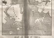
1840 map showing Cum-sing moon
this map published by the New York Observer in 1840 also shows the location of Cum-sing moon: https://gwulo.com/atom/38122