R.A.F. Unit Billets, No. 1 Calder Path [????-????]
Primary tabs
Submitted by Tymon Mellor on Wed, 2016-06-01 12:27
Current condition:
Demolished / No longer exists
Described in the 1950 Military Installations Closed Areas document as "House and garden on the corner of Macdonnell Road and Calder Path. Surrounded by a wall."
Photos that show this place
 1960 |
 1971 |


Comments
On IL 1380
On IL 1380. Where Wealthy Heights is located today
The building was used as a
The building was used as a School from the mid 1950s to when it was demolished in the mid 1980s to construct Wealthy Heights
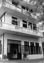
No. 1 Calder Path
No. 1 Calder Path was a 3-storey high sick quarters of RAF in 1946.
St. Paul's Co-ed College Council bought it in 1953, to use it as the campus of its affiliated primary school, which used to share the campus on no. 33 MacDonnell Road from 1927 to the outbreak of WW2.
In 1971, the primary school moved to the new east wing (I.L. 1937) of 33 MacDonnell. No. 1 Calder Path was left vacant since then, and redeveloped in mid-1980's to Wealthy Heights as it is now.
TN
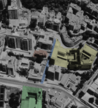
Location of the building at no.1 Calder Path
Though bearing the street number 1, the 3-storey building (red in the photo) used by RAF, then by SPCC until 1971, situated in the middle of Calder Path (blue). St. Joseph's College in green, and St. Paul's Co-ed in yellow.
In Michael Rogge's youtube footage ( My life in HONG KONG after WW2, 1949 (1) ), at least two types of wall could be seen along the eastern side of Calder Path.