Get Gwulo's books
Directory
Click on your area of interest to choose from over 30,000 pages about old Hong Kong:
- Images & photos
- View - View galleries - View new - Create - Forum topics
- View - Create - Places & buildings
- View map - View new - Create - Streets
- View map - View new - Create - People
- View - View new - Create - Organisations
- View all - View new - Create - Diaries & memoirs
- View - View new - Create diary - Create page - Events
- View - View new - Create - Jurors lists
- View - Type a page
Or choose a popular article:
User login
Timeline
A timeline of Places at this site.
This:
- Seven and Sixpenny Hill [????- ]


Comments
Seven and Sixpenny Hill
Henry Ching writes:
It was the quite steep path within Victoria Barracks running south from Queen’s Road almost directly opposite the entrance to the old Wellington Barracks. I believe that was the rate of pay of a private in the British Army.
Seven and Sixpenny Hill
HK Telegraph 2 January 1919 gave a few expanations given by readers of the origins of the Hill's name. An explanation given by one reader: 'At Home, any person found the worse of liquor, or drunk and incapable, is brought before the police court and fined 7/6 or an alternative. When any person walks up a steep hill such as leading to Government Headquarters, they always assume the zigzag gait like that of a drunken man. To anyone standing at the foot of the hill, they would appear to be in a state of intoxication and a fit person for the local exchequer to benefit to the extent of 7/6. Hence the soldiers have given this hill the name of Seven and Sixpenny Hill.'
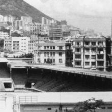
The eastern entrance to Seven and Sixpenny Hill (where the pillars are to the left of the trams)
7/6 hill
Henry Ching writes:
In Andrew Suddaby’s 1981 collection of photos, there is one captioned “Victoria barracks”. It shows a tram on Queens’ Road just outside the old Wellington Barracks. To the right of the tram there are some steps - these lead up to the steep path that was known to residents of my day as Seven and Sixpenny Hill.
Here's the photo:
This path is quite a bit further west than the hill that has the Ching Yi To barracks on top. Further confirmation comes from the HK Telegraph. The article Moddsey quotes is the result of a competition they announced on page 4 of the 1918-12-21 edition. It starts:
"SEVEN AND SIXPENNY HILL".
An interesting "Telegraph" Competition.
In our pictorial supplement today will be found an illustration of the hill leading to the Military Headquarters in Hongkong. This incline has been popularly known among successive garrisons as "Seven and Sixpenny Hill,” and it is now officially designated thus, as the painted sign seen on the photograph will show.
There must be an origin for the name. We have heard several explanations, some with an obvious smattering of fact and some quite otherwise. We are anxious to know what local humourists think about the matter and have therefore decided to offer a prize of two St. Andrew's War Bond tickets to the competitor sending in what is adjudged the most humorous, definition of the name. No entrance fee is [...]
Unfortunately the newspaper on MMIS doesn't include the pictorial supplement, so we can't see the sign.
Would the Military Headquarters in "the hill leading to the Military Headquarters in Hongkong" refer to Headquarters House, http://gwulo.com/node/5755?
The 1952 map clearly shows
The 1952 map clearly shows two paths, and I picked out the "Hill" based on the topography showing a hill between the two paths.
Paths & Places
I've split the barracks out to their own page: http://gwulo.com/node/33095
For the paths, if we look at the map there's a blue dotted line above the marker and a black dotted line below it. Are they the two paths you have in mind?
http://gwulo.com/node/33019#17/22.27691/114.16746/Map_by_ESRI-1952_All-M...
Re: Hill
I note Wattis Fine Arts has a map of Victoria Barracks from the 19th Century. Although the hill is not named there are paths that proceed up from Queens Road that appear to circle the hill
Location
On the 1956 Map Seven & Sixpenny Hill is labeled running directly up the east side of Victoria Barracks blocks A-E
re: location
Good to have that fixed at last. Please do you have a source / reference for the 1956 map?
I've nudged the marker over to Justice Drive, which I think is along roughly the same line as the old road.
Indigenous name of this hill
This hill was called 杉排 by locals. It was a site for logging. Googling 杉排 would lead you to more secondary sources.
https://www.urbandiarist.com/tc/stories/021/Did-you-know--Sau-Ping-share...