RBL 189 [c.1918- ]
Primary tabs
RBL 189 is marked as an empty site on the 1924 map at https://gwulo.com/atom/13018, but not on earlier Peak maps from 1912 and 1909. I've taken the mid point between 1912 and 1924 for its creation. Subsequently the following buildings have occupied the site.
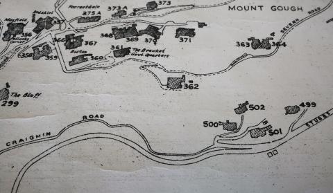
A mid 1950's map shows four buildings on the site. No names given, but numbered 499, 500, 501 and 502 The Peak.
The early 1960's map at https://gwulo.com/atom/15993 shows buildings in the same positions as the mid 1950's map, but they've been renumbered with No. 499 The Peak shown as 60 Peak Road, 500 The Peak as 66 Peak Road, 501 The Peak as 62 Peak Road and 502 The Peak as 64 Peak Road.
The latest Google Earth map shows the site having been completely redeveloped. Now Fung Shing Villa occupies the position of 499 The Peak/60 Peak Road, whilst Ondina Heights seems to cover the entire area where 500 The Peak/66 Peak Road, 501 The Peak/62 Peak Road and 502 The Peak/64 Peak Road once stood.


