1850/60's Praya Reclamation [1859- ]
Primary tabs
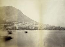
It started with this photo found on Gloucester Tower (Pedder Street near Des Voeux Road):

Tag showing 1865 central reclamation, by Klaus
Obviously, reclamation work was done prior to the 1890s Central Reclamation.
Interesting details can be found in Lin Song’s thesis from 2016:
On 20 January 1841, Navy official Edward Belcher led a fleet to land in Hong Kong, which marked a new page of history for this city. The surveyors of fleet found an elevated plain near the shore suitable for camping in the west side of the island. A road was built from the shore to the camp --- Possession Street.
Only five months after, the first land auction in Hong Kong was held on 14 June, 1841 in Macau (by Captain Charles Elliot). From the very beginning, British have claimed that all land lots will be at public auction, in a public notice in Gazette No. 1 dated 1 May 1841. Commercial lots along the waterline of the Central District were designated as Marine Lots. While lots, 200 feet landward, were designated Inland Lots, used primarily for residential purpose. Early grant plans showed the distances and the area of the subject lot in an "island map" style. It is obvious that from the very beginning, government realized the business values of the lands along the sea coastline, and defined them all as commercial purpose.
On this first auction (see also https://gwulo.com/atom/25566), 34 out of 50 pieces of land were sold out successfully, all marine lots, in freehold term: each had a 100 feet frontage along Queens Road and varying lengths to the winding coastline. Queens Road was the first road opened up along the coast, and the all the marine lots are located between the Queens Road and water front. The land lots were then much expanded and reclaimed from the sea, later, without paying rent to the government. The shoreline then became very irregular.
This can be considered as first round of reclamation land from the sea, although it was completely spontaneous, un-organized, and for private land lord’s good only. The effects can still be tracing from a few pieces of lands today, like HSBC site: no buildings are constructed in front of it, which constitute some valuable open space in Central area. The first trial of land auction was not well planned, because of the rush move and time limit. The newly arrived British General, Mr. Edward Belcher was too hasty to sell all valuable plots along the sea, and the results were directly and indirectly lead to next land reclamation very soon.
Nevertheless, the Government started reclamation works in this area. Some details are listed in a report for the extension of the MTR West Island Line:
During the early years of the Colonization of Hong Kong Island, the north shore was very narrow. The north coast included today’s Queen’s Road Central, which ran along the coast with piers and single-storey godowns lined along the waterfront. Since there were insufficient lands along the coast for further development to meet the increasing population on Hong Kong Island, reclamation was carried out from the west of Kennedy Town to the east of Wanchai.
The planning for reclamation along the north coast by Governor George Bonham started in the early 1850s. In 1859, reclamation along the coast of Sheung Wan was completed and Queen’s Road (Queen’s Road Central today) and Bonham Strand were formed.
From 1864 to 1866, reclamation was carried out along Causeway Bay waterfront and Bowrington District of Wanchai….
As mentioned in Song’s thesis, irregular (probably illegal) reclamation started in the early 1840’s. The government didn’t get any rent for these extensions. Furthermore, marine lots were divided and it turned out to be difficult to collect the rent. This led to governmental actions for consolidation of lots, but it took a quite long time until end of the 1880’s (see report below)..
Sources:
Song, L. [宋琳]. (2016). The heritage of reclamation : a cultural mapping of the historical layers of the Hong Kong Central waterfront. (Thesis). University of Hong Kong, Pokfulam, Hong Kong SAR. (http://www.epd.gov.hk/eia/register/report/eiareport/eia_1532008/EIA-pdf/Appendix/app%206.1.pdf)
Consultancy Agreement No. NEX/1023 West Island Line Environmental Impact Assessment Final Environmental Impact Assessment Report Appendix 6.1 (http://hub.hku.hk/handle/10722/241326)
Report from the Hong Kong Land Commission of 1886-1887 on the sale, tenure, and occupation of the crown lands of the colony.
(https://webb-site.com/codocs/LandCom1887.pdf)
Photos that show this place
 1865 |
 1868 |
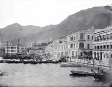 1870 |


Comments
I don't think Queen's Road
I don't think Queen's Road was formed by the 1859 reclamation:
In 1859, reclamation along the coast of Sheung Wan was completed and Queen’s Road (Queen’s Road Central today) and Bonham Strand were formed.
The 1845 map shows the Sheung Wan section of Queen's Road was already in existence then: https://gwulo.com/map-of-places#17/22.28596/114.14902/Map_by_ESRI-1845_H...
Queen's Road
David, I think you're right. I didn't check this thoroughly. I was sure Queen's Road East existed then, but it was also true for QR Central.
Obviously, the source (http://hub.hku.hk/handle/10722/241326) made an incorrect statement.