Man Kam To control point (1950s) [????-????]
Primary tabs
Submitted by David on Wed, 2018-04-25 13:58
Current condition:
Demolished / No longer exists
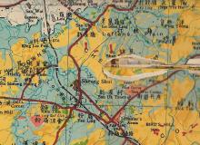
The old bridge across the river, linking Hong Kong to China. It is shown clearly on the 1952 map:
https://gwulo.com/node/40970#15/22.5396/114.1251/Map_by_ESRI-1952_All-Ma...
Photos that show this place
 1936 |
 1946 |
 1949 |


Comments
Man Kam To
i think the Man Kam To border crossing point also appears here
Well spotted - looks like the
Well spotted - looks like the previous two photos are of that location too:
https://gwulo.com/atom/20154
https://gwulo.com/atom/20155
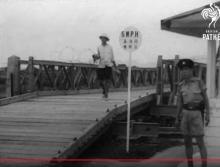
Bailey Bridge, 1946-1976
Notes from Moddsey:
The Bailey bridge at Man Kam To constructed in 1945 remained in use till 1976. The book 'Feeling the Stones: Reminiscences by David Akers-Jones' mentions the removal of the old rusty bridge here from Page 99. Had the thought that Chicks Bridge was so named due to the transport of livestock (particularly chickens) across the border.