c.1950 Central from the harbour
Primary tabs
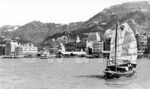
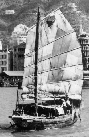
We'll start the new year with a popular view - Victoria Harbour with a junk sailing by, and Hong Kong Island in the background.
Where: The photo shows buildings along Connaught Road in Central, and the hillsides beyond.
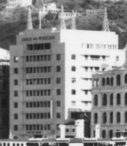
When: The buildings along Connaught Road were built in the 1890s and 1900s, on what was then newly-reclaimed land. When this photo was taken, most of those buildings were still standing, with one exception:
This box-shaped building was initially known as Electra House, later as Mercury House. As the name on the building shows, it was built for Cable and Wireless, who moved into the new building in February, 1950.
So the photo was taken in 1950 or later. Not much later though ...
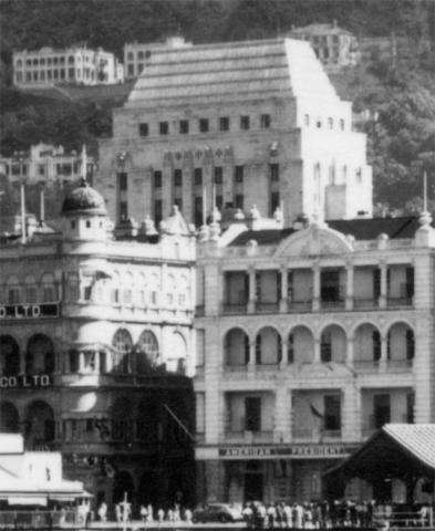
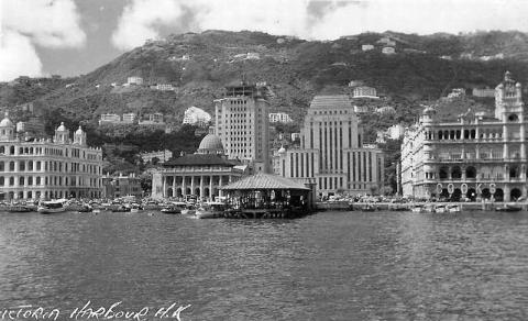
HSBC's headquarters building is clear to see, standing head and shoulders above the buildings along the seafront. In views from the harbour like this, we're used to seeing a slightly taller neighbour on the left, the Bank of China. Here's a photo showing the Bank of China building under construction.
As that construction work was finished in November 1951, I'll guess the main photo was taken in mid-1950: Electra House is finished, but there's no sign of the Bank of China yet.
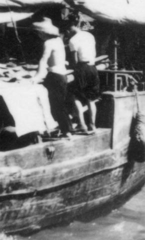
Who: Look at the two sailors on the junk. They must have had excellent balance, as there aren't any ropes or railings to stop them from falling in to the sea.
I love to see the sails on the old junks like this, all patched up, and often with as much hole as cloth. This one is in pretty good shape though, with a patchwork of repairs, but only one small hole at the top.
What: I've got a few questions I welcome your help with.
Generations of ferries
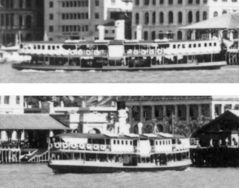
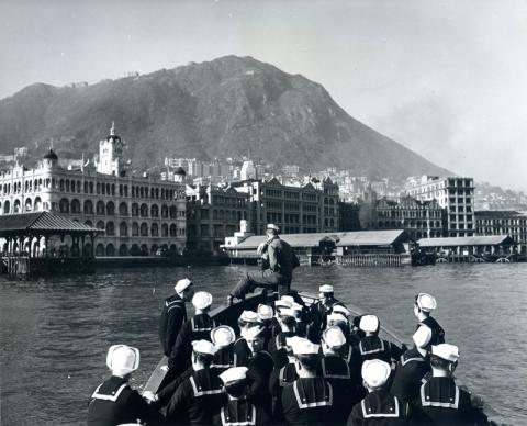
The Timeline of Hong Kong Trams is a helpful tool when trying to put a date on a photo that shows old trams. I wonder if there are enough differences in Star Ferry designs that they could help us to date harbour photos in a similar way? As an example, compare the two ferries in this photo.
If we look at the upper deck, one has the enclosed sections at each end, while one has them in the middle. Modern ferries all have the enclosed sections at each end of the upper deck, so was there a specific year when the design changed, and no more enclosed-middle ferries were built?
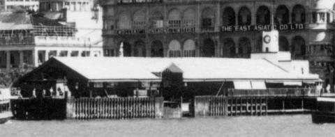
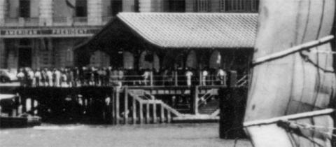
When & why did Blake Pier lose the end of its roof?
The old Queen's Pier is clear to see between the two ferries. Its roof slopes in two directions, both along and across the length of the pier. A roof with that design is called a hip (or hipped) roof.
In the centre is the Star Ferry Pier. It has the simpler, gabled roof, as the roof only slopes in one direction, across the pier.
The third pier is Blake Pier. Though it is mostly hidden behind the junk's sail, the end facing us shows it has the same gabled style of roof as the Star Ferry's pier.
But this 1925 photo of Blake Pier shows it originally had a hipped roof, like Queen's Pier.
So... does anyone know what caused the hipped end to be removed, and when did it go?
I guess the cause was wartime damage to the roof, but did the damage happen during the fighting in December 1941, or in one of the American bombing raids that followed?
And I've read a suggestion the end of the roof wasn't removed until the late 1940s, but this 1945 photo shows Blake Pier at far right with the hipped end of its roof already missing.
Buildings along Magazine Gap Road
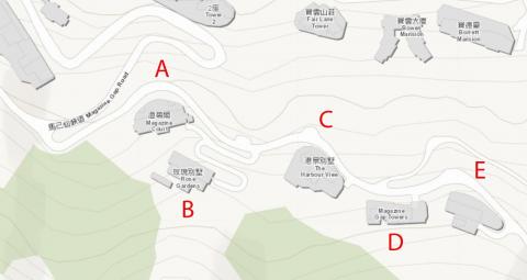
Finally, I'm interested to learn more about the group of buildings along the section of Magazine Gap Road we can see, just above the junction with May Road. Here's a modern map of the area, with the five building sites labelled.
It's the section of Magazine Gap Road just after the junction with May Road. After passing that junction, Magazine Gap Road turns around a sharp hairpin bend, then curves around three ridges in succession, /\/\/\.
In the 1920s, a plot of land was levelled on each of those ridges, just above the road. Houses were built on them at sites A, C, and E. The houses are described in the PWD's annual report for 1922:
The erection of 3 pairs of semi-detached European houses for the Eastern Extension Telegraph Company on I.Ls. 2308, 2309 & 2310, Magazine Gap Road, was completed.
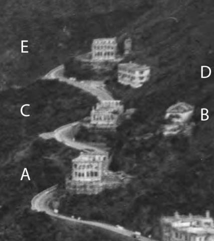
Like Blake Pier, these buildings also suffered during the war years. Here's how they looked in 1946.
In 1946 the three buildings A, C, and E are just roofless shells, probably damaged by a combination of shelling by the Japanese during the fighting, then looting in the years that followed.
Move ahead to the 1950 photo, and see how quickly the area was re-developed.
Site A still shows signs of its ruined building, but site C has been cleared, and site E already sports a new, three-storey building.
Today's buildings are different again, so I'm guessing there have been three generations of buildings on each these sites: pre-war, post-war, and modern. If you can share any memories or photos of these buildings, especially the earlier generations that have vanished, they will be gratefully received.
Gwulo photo ID: EM001
Further reading: The section of the Central's seafront shown above is covered in more detail in photos #1, #18, and #22 of Gwulo's book, Old Hong Kong Photos..., Volume 2.
Trivia: The Eastern Extension Telegraph Company, original owner of those houses on Magazine Gap Road, was a British telegraph company, with its offices in the building that preceded Electra House. In the late 1920s, Britain merged its various communications companies into one, and in 1934 that company was given a new name, Cable & Wireless.




Comments
The five properties A-E today
The five properties A-E today are 5 & 7, 9, 11 , 15 & 17 Magazine Gap Road. The street numbers seem not have changed since the houses’ construction so I have created places for the missing locations and a timeline for each site below:
Building A - 5 & 7 Magazine Gap Road
1st Generation Building was completed in 1922 on IL 2308 for the Eastern Extension Telegraph Company (Source: 1922 PWD Report) Destroyed during WW2 - either during the battle or by subsequent bombing - Demolish date set as Jan 1945
2nd Generation building was completed in the 1950s (still a ruin in May 1949 aerial photo with no sign of construction)
The current building is called is Magazine Gap Court - completed in February 1983
Building B - 9 Magazine Gap Road
1st Generation Building was likely completed by late 1920s on IL 2327. The building survived the war, the same building layout appears on the 1957 city plan.
The current building is called Rose Gardens - completed in January 1964.
Building C - 11 Magazine Gap Road
1st Generation Building was completed in 1922 on IL 2309 for the Eastern Extension Telegraph Company (Source: 1922 PWD Report)
2nd Generation Building was called Harbour View Mansions,11 & 12 Magazine Gap Road. Completed c1950 - under construction in aerial photos from May 1949. I assume it was demolished c1990 to build the current building.
Current building is called The Harbourview - completed in September 1995
Building D - 15 Magazine Gap Road
1st Generation Building - I am unsure as to exact completion date but exists on the city plans from the late 1920s. The building seems to have survived the war. On the 1957 map the building was called Mohni Mansion No 15A & 15B Magazine Gap road. Demolished c1965 to be replaced by Magazine Gap Towers.
Current Building is Magazine Gap Towers, completed in September 1967.
Building E -17 Magazine Gap Road
1st Generation Building was completed in 1922 on IL 2310 (Source: 1922 PWD Report). Destroyed during the war.
2nd Generation building was constructed c1950 (under construction in May 1949 aerial photo). Demolished c1967 to be replaced by Magazine Heights
Current Building is called Magazine Heights, completed in February 1968. - Current Lot number is IL 8021
Some Post War Pictures
The ruin of 5 Magazine Gap Road. the wall facing the photographer is the back of the building.
5, 9 & 11 Magazine Gap from Bowen Road. The ruin of 5 Magazine Gap Road can be seen to the right of the top of the crenellated tower. 9 Magazine Gap Road is to the left, above the corner tower of the same building. Part of the ruin of 11 Magazine Gap Road can be seen in the trees to the left of No 9, above the gap between the buildings in the foreground.
The ruin of No 11 Magazine Gap Road.
1962 Magazine Gap Road
Buildings labelled A - E as above
Thanks very much for filling
Thanks very much for filling in the blanks for those buildings along Magazine Gap Road. Fingers crossed we hear from some people who lived in them and can give us some close-up photos.
Ferry memories
My memory does not distinguish between 1939-1941 or 1947-1949 when it comes to the Star Ferry. I recall that on the run going from Mui Woh to Hong Kong, viewing the lower deck for'ard, which was wide open. There were usually some shallow, large diameter wooden vats containing live crabs going to market. Different colors of crabs. In those days on the Hong Kong bund right next to the water a common sight was a large black manta ray laid out.
Arrival at Mui Woh was interesting. Due to shoals, the launch did not dock, but anchored out a short distance in the bay. A large extra long unroofed sampan came out with passengers leaving and picked up passengers debarking. It was rowed with one single long sweep stern oar by one little old lady. The end of the oar was on a rope tied to a bolt ring onthe deck. The little lady would keep one foot on the rope for compound leverage. The boat was run aground a little bit on the sand of the beach. Passengers leaped out, from just aft of the prow, often splashing in a few inches of water.
Regards, Don Ady
A nice view of the post war
A nice view of the post war Magazine Gap Road buildings above bank of China just to the left of the ferry pole:
May and Magazine Gap Roads
From an unfinished project on May and Magazine Gap Roads houses. This is a cropped image from an old postcard from 1951-1955.
Unfortunately, it has a different angle compared to the one by Hedda Morrison making the compaison a bit tricky.
I believe it shows the houses on David's photo with the new building E (No.17), but an empty lot A (No. 5).
Where was the Catholic Club?
Hi David,
I was stationed at Far East Farm Camp, 21st milestone Castle Peak Road for three years, 1953 to 1956.
When off duty I often enjoyed a prawn curry, the best in town, at the Catholic Club, which was somewhere along towards the Macau ferry pier. Above you show a photo of US Navy sailors going ashore, and I am pretty certain one of the buildings along the waterfront in the background would have housed the Catholic Club. Do you know which one? Looking at Google Maps I can see there has been an enormous amount of reclamation from the harbour, and that today it is several streets inland, and called the Catholic Centre, however, I am convinced it was on the waterfront in 1953.
I always enjoy your data on Hong Kong, old or new. Keep up the good work,
My regards,
Jim Jacobs
There is more information and
There is more information and photos about the Catholic Club location here. From the description given there it was located in the King's Building. The map here confirms the location as King's Building 9 Connaught Road