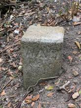
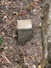
WDBS, High West #6 [????- ]
Primary tabs
Submitted by dailoban on Mon, 2020-03-02 13:50
Current condition:
In use
Walking along Harlech road yesterday, I came across this boundary stone right below a drainage bridge below the path.


Comments
Thanks for posting about this
Thanks for posting about this. I thought we'd found all the military boundary stones around that area but this is further east than the others. I wonder if they followed Harlech Road right back to its start?
Good to hear from you again too. I see your first post to the site was back in 2009!
Hey David,
Hey David,
Always a pleasure. I normally run lugard at night but decided to have a stroll yesterday afternoon and check out some of the structures. The bridges that were built under the pathway are quite beautifully constructed. I'll have a look out for some more stones.
Re: War Department Boundar Stones along Harlech Road
Hi David,
As a coincident I went down to the OP at the end of Harlech Road earlier today and sort of saw four such stones. Three above the path and one below it. I may have marked them here before but have forgotten if I have tagged them.
On the other hand, while walking along Harlech road before reaching High West, I think I may have recognize two paths that may lead down to the former fireing range, much overgrown nowadays. Both of them have an identical concrete block besides the steps. The same kind of concrete blocks are also lining the foot path towards the targets on High West.
T
Re: War Department Boundary Stones along Harlech Road
Hi Thomas, we've only got three stones marked so far along the road down to the OP:
https://gwulo.com/taxonomy/term/668/places-map#16/22.2726/114.1374/Map_by_ESRI/100
So if you're back that way and can add a Place for the fourth, that'll be a good addition.
I hadn't paid attention to the concrete blocks along Harlech Road - something to look out for next time I'm there. (Which used to be at least once a month when we lived on Pokfulam Road, but doesn't happen often since we moved to Kowloon.)
Regards, David
Re: War Department Boundary Stones along Harlech Road
Hi David,
The one I spotted last Saturday is way higher up the slope, maybe more than 3 to 4 metres from Harlech Road. The existing marked ones are generally on the road side, quite easy to spot. I will have to go back and try to estimate the location again on the spot.
As for the concrete blocks, here's one of them besides a tree, next to the steps going down.
T
Re: War Department Boundar Stones along Harlech Road
Hi David,
Looked up the older entries. You have marked stone #10 and had gone up to it mentioning there is a square hole there. The one I saw was before reaching #10.
That was before reaching the 280m towards PCCW emergency phone sign post. In the street view you could see both the post and the stone in the wide angle shot. Does that look like a #9 to you? Together with the newly located #6, where is #7 & #8? Interesting.
One thing, the locaton of the street view is very close to your marker of #10.
T
Yes I noticed these concrete
Yes I noticed these concrete blocks too. Each set of steps leading down to the old firing range has them.
You're right that they are the exact same type of blocks that are lined up on the way to high west.
They look like they would have had a signpost in them, or something,as there are rusted iron remnants in the top centre of each block.