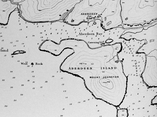
Section of "(1845) The 4 inch 'Collinson' Map (reduced).", shown in Plate 2-1 of the "Mapping Hong Kong" book.
1845 Map of Aberdeen
Primary tabs

Submitted by David
Date picture taken (may be approximate):
Wednesday, January 1, 1845
Gallery:
Connections:
- 1845 Map of Aberdeen shows Place Aberdeen Harbour [????- ]
- 1845 Map of Aberdeen shows Place Staunton Creek [????- ]
- 1845 Map of Aberdeen shows Place ap lei chau duck egg (west), aka fung shui egg, aka careening island. [????- ]
- 1845 Map of Aberdeen shows Place Ap Lei Chau Duck Egg (east), aka Fung Shui Egg. [????- ]


Comments
Re: 1845 Map of Aberdeen
Hi there,
The old map is fairly accurate. Actually the 1964 Aerial photo looked very much the same except for the Aberdeen bay side. After seeing this map I totally understand why it was called Shek Pai Wan (石排灣) as there is really a pile of rock in the middle. The old main road today more or less ran along the previous coast line.
Best Regards,
T
depth soundings
It's interesting to see the depth soundings and the fact that the harbour rarely extends below 10 metres.
Mount Johnston
I wonder who Mount Johnston was named after. Possibly AR Johnston, who took over from Elliot as acting governor in June 1841 (according to Eitel).
Re: Mt Johnston
Yes, A R Johnston would be the most likely candidate.
Re; Johnston
Also just noticed that he has a chapter to himself in Endacott's Biographical Sketchbook of Early Hong Kong, which notes that he was in charge of HK during the building of bridle path to Aberdeen.
Aberdeen lagoon
Lagoon to east of Aberdeen
Does this refer to Staunton Creek,which was pretty foul well into the 1960s.
Yes, you can see it on the
Yes, you can see it on the top corner of the map above. Pretty sure that would be it.
The creek
I've added a Place for it above, where you can see a couple of photos.
Regards, David
1845 Aberdeen Map/chart depths
I do not think the charts of 1845 vintage used metric, more likely fathoms. One fathom = six feet.
rehide@hongkongescape.org
www.hongkongescape.org