Shek Shan, near To Kwa Wan [????-????]
Primary tabs
Submitted by simonarris on Thu, 2021-12-30 10:32
Current condition:
Demolished / No longer exists
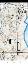
Both the 1896 and 1903 overlays in Gwulo's Marvellous Mapping Tool show a place called Shek Shan near Ko Shan and the confluence of Chatham Rd North, Ma Tau Wai Rd and Kowloon City Rd.
There is no Chinese lettering so i can't tell if the Shek stands for Stone or Snake (two common usages).
I can find no reference to this area, which I'm taking to represent another member, albeit minor, of the " lost hills of Kowloon".
Does anyone have any information to share?
Thanks in advance!
Photos that show this place
 |


Comments
Shek Shan, near To Kwa Wan
There is a crop from the 1896 map at https://gwulo.com/atom/41817.
Sorry, i haven't yet worked out how to think this properly
Re: Shek Shan
Suggest to view the maps at https://www.hkmaps.hk/mapviewer.html and select the 1903.1 map. There is a Quarry Hill to the west of To Kwa Wan as well as quarries to the south west. More here
Re: Shek Shan
Thank you moddsey, that helps. Good topographic detail and clarification in the Chinese. I guess the place marked was more like a processing area for the quarries "shek shan" than a "shan" itself. Much appreciated