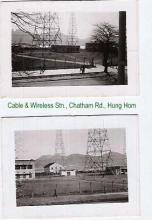
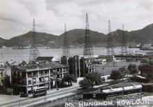
Cable & Wireless Station, Hung Hom [c.1932-c.1967]
Primary tabs
Submitted by David on Tue, 2010-07-20 12:06
Current condition:
Demolished / No longer exists
Date Place completed:
c.1932-01-01 (Year, Month, Day are approximate)
Date Place demolished:
c.1967-12-31 (Year, Month, Day are approximate)
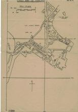
The station appears on a 1964 map of Kowloon (Plate 4-8, Mapping Hong Kong), covering a roughly square piece of land. NW boundary was Chatham Rd, and NE boundary was Winslow St, running between Chatham Rd & Gilles Ave.
There's what looks to be several aerial masts in the same area on a 1947 map (Plate 4-7), though at that time it only covered appx half of the later site.
Can anyone tell us more about when it existed and what it was used for?
Photos that show this place
 1945 |
 1952 |
 1953 |


Comments
Re: Date of demolition of the radio stations
Hi there,
I believe we could refer to history of KCRC as well as the first Cross Harbour Tunnel for more information. The radio stations were demolished way before the railway was diverted to Hung Hom and before the nework of flyovers to be used by the Cross Harbour Tunnel back then.
That section of old Chatham Road does not exist anymore. The section of Chatham Road had been widened and rebuilt. Before the Hung Hom Terminus was built the railway turned a bit westward towards the present day location of Hong Kong Polytechnic University after exiting the short tunnel under Homantin. It passed through their present day soccer field and swimming pool then went towards Tsimshatsui.
The old railway should ran west of the present day Hong Cheong Road flyover, with a live stock depot. The depot was smelly at best, and smells really bad in a hot and windless day like sometime before last week.
Best Regards,
T
Re: Date of demolition of the radio stations
Thanks Thomas.
This photo, c.1949, from IDJ shows the old layout of the area. The smaller patch of land I mentioned is visible, but it's not clear if there were aerial masts there.
Radio Hong Kong in Hung Hom
Hello there.
The station first appeared in 1932 in the Blue Book, p.548 (Ze 6) (http://sunzi.lib.hku.hk/hkgro/view/b1932/51932041.pdf), marked as under construction. If I am not mistaken, Radio Hong Kong (English ZBW and Chinese ZEK medium wave services) transmit through this Cable & Wireless station from 1932 until 1966/67, which corresponds to 'No. 25: ZBW Broadcasting Station, junction of Chatham Road and Gascoigne Road' on the Kowloon Peninsula on the 1945 map (https://gwulo.com/node/38765#11/22.3200/114.1700/Map_by_ESRI-Markers/100).
The 1954-55 Annual Departmental Report of RHK [available at The Chinese University] said the New Territories and the south of Hong Kong Island had poor reception, the latter due to 'intervening high ground'. It also noted that:
As for why Cable & Wireless was involved: the company was nationalised by the British government, and the government could certainly use their resources for its own station. Later in 1950, RHK engineering works were outsourced to Cable & Wireless, accoring to RTHK - 50 years: Broadcasting in Hong Kong from 1928-1978.
I am not sure about the exact time of its demolition, but RHK's 1965-66 Annual Departmental Report should give some clues:
Hope that helps.
re: Radio Hong Kong in Hung Hom
Thanks for the extra detail. I've updated the years from 1946-1970 to c.1932-c.1967.