Everything tagged "border" | Gwulo: Old Hong Kong

Everything tagged "border"

Lok Ma Chau – Hong Kong’s Most Photographed Man ?

LMC-Lookout-Girl-Pointing.jpg

Date picture taken (to nearest decade for older photos): 
1966

Close up of a small girl pointing towards Chinarail's friend holding his camera .  Picture is extracted from a larger photograph taken at Lok Ma Chau Viewing Point in 1966. Read more on this Forum Topic HERE 

Lok-Ma-Chau - Lookout - The View Today ( 2019)

Date picture taken (to nearest decade for older photos): 
2019

The duck farm ponds and rice fields across the border have all given way to a high-rise Central Busiess Dsitrict of Futian in Shenzhen. Read more about the former years on this Forum Topic HERE 

Lok Ma Chau - Map of border region c.1960

Date picture taken (to nearest decade for older photos): 
1960

Extract from a late 1950s British military map showing the  border region near Lok Ma Chau. The Viewing Point was ( and still is) accessible up a short  road leading to the top of a small hill  on which Lok Ma Chau police station is located. The viewing point overlooks  the border ,  marked by the Shum Chun River. You can read a description of what met your eyes back in 1966 on this Forum Topic HERE 

Lok Ma Chau - Small Cantonese girl with baby boy strapped to her back

Date picture taken (to nearest decade for older photos): 
1966

Close up of a small girl.  Picture is extracted from a larger photograph taken at Lok Ma Chau Viewing Point in 1966. Read more on this Forum Topic HERE 

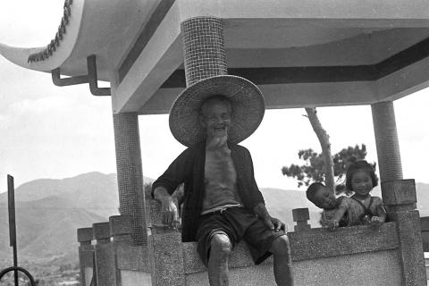
Lok Ma Chau – Hong Kong’s Most Photographed Man ?

Date picture taken (to nearest decade for older photos): 
1966

During the 1960s-1970s tourists and other visitors to the Lok Na Chau Viewing Point would invariably be met by this old local farmer and an entourage of his grandchildren. But beware if you took a photograph …. you can read why on this Forum Topic HERE )

Lok Ma Chau Viewing Point - Watch your pockets !

Date picture taken (to nearest decade for older photos): 
1966

During the 1960s-1970s tourists and other visitors to the Lok Na Chau Viewing Point would invariably be met by a Hakka man and an entourage of his grandchildren. But beware if you took a photograph …. you can read why on this Forum Topic HERE )

Closed Area Crossing-Chicks Bridge

Date picture taken (to nearest decade for older photos): 
1949

A sign next to the vehicle declares this to be CHICKS BRIDGE. Presumably the Bailey Bridge's erector

Present-day Lin Ma Hang Village

Date picture taken (to nearest decade for older photos): 
2016

Picture was taken from the hill of Wang Lek on the west side of Lin Ma Hang Village.  

HK border in NT 7.JPG

Date picture taken (to nearest decade for older photos): 
1948

This frame in the 'round robin' trail of Roland Brooks follows on from:

Pages

Subscribe to Everything tagged "border"